The Richat Structure
Tuesday, 19th July 2005 by Alex Turnbull
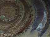
The Richat Structure in central Mauritania is a stunning geological structure 50 kilometres across (Wikipedia entry). Once thought to be an impact crater, it is actually a sedimentary formation that has eroded flat over many eons. Apparently there's a hotel smack-bang in the middle of it.
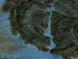
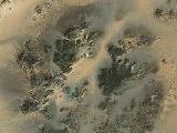
There are also several other similar structures in the Sahara, such as the Jebel Uwaynat (thumbnail #2) which was used to define the borders of Sudan, Egypt and Libya, and also the Brandberg Intrusion in Namibia.
Even though none of these features are in high-resolution, it's well worth zooming in a bit, as they're perhaps even more fascinating to look at closer up.
Thanks to Pat Scaramuzza, Peter Nordstrom, GeMatt and Kai Huebner.
About the author
Alex has decided that his title will be Senior Vice President of Stuff.
Absolutely stunning. I swear geography teachers the world over are on their knees thanking the google gods! Personally, I’ve wasted 3 hours tonight alone on google earth!
amazing
A desert polka party?
View Placemark
Posted over a month ago with different comments. If one posts anonymous does the post get tossed? WTF?
Peter Nordstrom?! From Mercer Island?! You twit, I’ll sick that fat mobster kid from South Mercer on you! Steal MY post I tell ya…..!
FrankenPengie, anonymous comments are just as likely to get posted. When I originally wrote this post, these were all the people who had submitted. Better luck next time 😉
View Placemark
That’s a bit northwest from the second location. What in the world might that be? It’s clearly visible from quite far in space, and casts some sort of a blue trail towards southeast.
I thought it would be some large lake of oil with oil-colored sand flying with the wind. But i guess it’s not. 🙂
I’d say that was some kind of volcanic mineral – not oil – and then I just fould this:
http://www.fjexpeditions.com/frameset/waunamus.htm
It’s a volcano in Libya
>A desert polka party?
Looks like irrigation farming circles. A bundle of them.
Weird to think that 12 thousand years ago or so, before the end of the last ice age, the Sahara was mostly green fields and grasslands – much like the central US today. I wonder what the Richat Structure must have looked like then?
There have been some facinating ruins of cities and settlements found in the sahara, even canals, but they’re so hard to get to that excavation has been minimal. Having lived in the desert myself (Phoenix, AZ) I can understand not wanting to go about digging holes in the heat.
Otter
Alex, Thanx!
The Sahara is clearly too full of nice suprises.
About the polka party, take a look here
I am brazilian, and i really like of the photos. the more impressionant thing that i found in this web site was the Egyto’s photos. very pretty there! 🙂
This should be in the Egypt section, not Namibia!
There are similar structures at:
26.00.00.00 N and 2.00.00.00 E
These landforms share a same but less symmetrical structure with the now famous richat structure…
Atlantis???
why is it blue…i see that some say mineral or lake? has any found any websites with proven info…this is a beautiful site
Atlantis was located in an ocean wich at the time of the Greek was not navigable ? Could this really be the atlantic ? or the ocean described could have dried off and filled with sediment and sand; like the sahara where a whale fossil have been found near Egypt.
I discovered this hole one day just panning my way across Africa. Turned on the GE Gallery layer, and behold, there were answers. Cool.
there is some scientific explanation for this structure… There is something called folds that exists commonly in sedimentary rocks.. There are two kinds of folds.. Anticline and syncline.. If it is a doubly plunging anticline or syncline , it appears as a concentric circle in satellite imagery.. Actually it is a 3D structure extended deep into the ground.. Usually these kind of structures prove good source of ground water.
don’t look at what they are telling you are circles… follow the ridges and see the spiraling out pattern and the conclusion point as a blast area… think in terms of an atom smasher creating a black hole and brief fission, noted by the eletrical discharge patterns… this is what swizerland is going to look like if they pursue trying to split atoms