The Hampton Roads Bridge-Tunnel
Wednesday, 20th July 2005 by Alex Turnbull
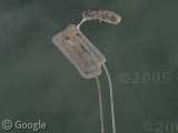
Here's the Hampton Roads Bridge-Tunnel, because it's been a while since we had a bridge. Er, I mean tunnel... no, wait, two bridges! Or is that two tunnels?
Frick.
The Hampton Roads Bridge-Tunnel is a combination of two bridges and two tunnels, connecting Hampton and Norfolk in Virginia (I think that's right anyway, but perhaps the Wikipedia entry can clear it all up for you).
Anyway, it's pretty cool - lots of cars on there coming in and out of either end (or is that either middle?).
Oh sod this. I give up.
Thanks to Tiger, Brad, DanielMaui, John Drummond and Ben.
About the author
Alex has decided that his title will be Senior Vice President of Stuff.

Hampton Roads Bridge-Tunnel (Roads to the Future)
Perhaps this helps. Two pairs of bridges to the artificial islands that are the ends of the pair of tunnels.
Excellent! I think this is the bridge that gets confused with the Øresund bridge I posted a couple of weeks ago.
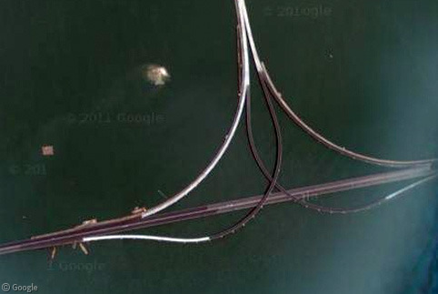
The Hampton Roads Bridge-Tunnel is okay, but a relatively short distance to its east is the far longer Chesapeake Bay Bridge Tunnel, so long it can be shown in its entirety only with a very low-resolution view:
View Placemark
There are sections of the Chesapeake Bay Bridge Tunnel where motorists can see no land at all, just water and the bridge itself.
Follow the highway to the south, and there is a raised drawbridge:
View Placemark
James: not quite; the one that gets confused with the Øresund is the Monitor-Merrimac, which is further west. (If you click on the image above you can see the MM off to the left.)
I’ll second Peter – the Chesapeake Bay Bridge Tunnel is much more impressive, size-wise. Until recently it was only 2 lanes, one north and one south – whizzing by oncoming traffic at 60 or 70 mph on a bridge 8 miles from land with no shoulders was quite the interesting experience.
Especially in a hurricane. With waves breaking over the side of the bridge at the tunnel entrances. Yea, that was a fun honeymoon.
The little kidney-shaped extension off of the bridge-tunnel island in the thumbnail is Fort Wool:
http://www.geocities.com/hrforts/Fort_Wool/history.htm
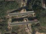
There’s another almost-identical bridge-tunnel just to the west of this one, and then another bridge further up river, but after that, if you want to get to the other side of this river, it’s a LONG drive to get to the next crossing…
Anybody know what this place is? It’s just to the right of the north tunnel opening…
Jen, A quick google turns up Fort Monroe, which has a moat and so fits the bill I think 🙂
Or you could just go to Map mode and zoom out to the 3rd notch, and it says the name of the fort right there…
Doh!
You can see some naval ships south west of the tunnel. Some are aircraft carriers.
View Placemark
Is Fort Monroe still an active US Military base or a park? Either way the Trace Italiane design is very beautiful.
Chris–
Active military installation, but according to Wikipedia, the original fort was built in 1834.
Alex – thanks Lurlock – darn! I went into Map mode for street names but didn’t go back enough notches.. thanks for pointing it out!
Fort Monroe is currently active, but is on the current base closure list. The very interesting part is that they were trying to save the installation from closure by drawing attention to the fact that with a moat and thick walls, the location is extremely suitable for office buildings that require high levels of physical security!
From wiki: “The reason the bridge has a tunnel instead of a more cost effective drawbridge to allow the passage of boats is because if destroyed in wartime it would not block off the coming and going of military vessels.”
cold war paranoia, anyone?
Yes that is Fort Monroe. And it is on the closure list. The city of Hampton is looking at what to do with it once it closes. The battle of the Iron Clads happened just of shore from the fort. If memory serves me, Jefferson Davis was inprisoned at the fort.
Looking around the area with the Hybrid on, you can see eBay Bloulevard… I guess you really can buy anythin on eBay. View Placemark
Hi, I live in the Hampton Roads area and came across your site. That little island is, indeed, Ft Wool, as indicated above by another reader.
http://www.geocities.com/hrforts/Fort_Wool/
The Chesapeake Bay Bridge Tunnel is actuall 18 miles long. When Ft Monroe closes, we hope they keep it as a museum, as it is now. Yes, it is an active Army Post now, but part of it is a museum. http://147.248.251.93/monroe/sites/local/default.asp
There are many bridge tunnels around the hampton roads area: CBBT, HRBT, Midtown, and the Downtown tunnels. The CBBT is 17.5 mi. long and the oldest. 3.5 mi. from VA Beach there’s a restaurant and fishing pier on the first island of the CBBT.
P.S. B.R.A.G. has closed Fort Monroe.