Montmorency Falls
Monday, 25th July 2005 by Alex Turnbull
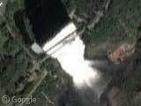
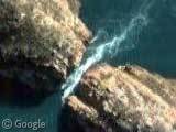
At 83 metres high, the Montmorency Falls in Quebec are 30 metres higher than Niagara Falls. Apparently there are staircases that allow visitors to observe the falls from different vantage points... Not our vantage point though!
The falls look absolutely stunning from up here, but make sure you compare the Google image to the shot posted on Wikipedia so that you can really appreciate what you're looking at. Also note the suspension bridge over the crest of falls, where I imagine you really do get a superb view. (More info at Wikipedia)
Thanks to Mathieu Jobin and Donald A. P.
About the author
Alex has decided that his title will be Senior Vice President of Stuff.
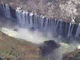
I visited Quebec once on vacation and can say that this is indeed an incredible waterfall. If you’re physically up to it, you can go all the way around the falls via a chairlift (west bank), across the foot bridge over the top of the falls, along the northern and eastern edges, down several long flights of stairs, and along the east bank. Incidently, there is also an observation point quite close to the bottom of the falls; in the summer it’s quite refreshing.
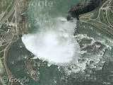
Tidbits of interest: The orange stuff to the east of the falls are logs that have floated over the falls. In the winter, portions of the falls freeze, making huge sheets of natural ice “sculptures.” There are many tiny little waterfalls along the west wall that are too small to make out through the greenery from this height. You can see the falls for many miles to the south. I’ve got a cool picture on the Ile d’Orléans (View Placemark) in which you can see the falls clearly.
I tried to look at these falls with Google Earth to get a 3D view but there is apparently no elevation info – the entire area shows 0 ft!
In summer there is an International firework competition around this fall. Peoples use firework, water, light and music in this unique place. More info and very nices photos here -> http://www.lesgrandsfeux.com/en/accueil/index.php
Esquif is right. The Loto-Québec International Fireworks Competition (Les Grands Feux Loto-Québec in French) is a pyromusical competition standing each year at the end of the summer and it goes on no matter what weather there is (except for this year- they had to stop China’s show in the middle of the representation because there was too much rain). I’ve gone there twice this year (Canada and Great Final), Canada won! Patrick is right too- the falls partly freeze during the winter, and at the bottom of the falls the scum also freezes to form what we (Quebecers) call ” Le Pain de Sucre (The Sugarloaf) ”.