Antarctica Pixellation
Tuesday, 26th July 2005 by Alex Turnbull
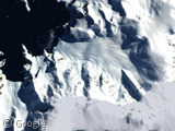
Check out this little bit of pixelly weirdness down in Antarctica, not very high-resolution of course (there's a lot of not-very-much to see down that way I believe), but it means we can finally have an Antarctica category!
![]()
Thanks to Winterfresh for sorting us out (And an additional, belated thanks to Dustin, hac and the very first person to submit this, Twombly). Sorry guys, will be more thorough next time!
About the author
Alex has decided that his title will be Senior Vice President of Stuff.
Two more examples… I think someone was just darned lazy when it came to having to fix these errors. 😉
Example 1
Example 2
Does this (the pixalation) indicate that people over at Google are working on the Antarctica imagery?
Anyone know where the big ice chunk that broke off a couple years ago is?
that’s ace! and quite informative – you see the large sheet of flat ice to the south and east is the Ross Ice Shelf, in New Zealand’s Antarctic Claim.
Now, take note of how the edge of the pixelly bit heads off eastward almost like a cliff, even crossing into the sea, where it becomes much more recognisable as the relief information that google puts in all the low res ocean bits. Trouble is, this is one bit of relief that doesn’t stay still!
My guess is that as the Ross Ice Shelf changes shape, the images and relief information – taken at different times – don’t match up, causing the modelling algorithm heartburn and creating this interesting effect.
Also, notice how vertically strecthed up the google watermarks are!
That Iceberg – known as B15 and the piece that broke from it B-15A, broke off this exact area – the Ross Ice Shelf. It caused trouble when it lodged a little further up McMurdo Sound, which is the bay we’re looking at here. McMurdo Station (US) is just near the notch between the Ice shelf and solid land.
B-15A was about one and a half times the size of the big square chunk of ice now jutting out into the bay. more
I think that pixelating has something to do with google switching googlemaps to Mercator projection, which no longer squeezes the maps of some northern cities (or southern) together. You might have noticed how the satellite images of the north didn’t match the map, but were squeezed flat.
I don’t know the name of that projection, but the new one seems to be Mercator, which really inflates high latitudes. I wonder if it also make satellite images from the north and south relatively larger?
Well finally I’m able to see my own neighborhood around helsinki, finland with the streets and blocks as squares as they are for real. 🙂
Well apparently the old projection of the satellite photos was a Plate carrée projection. More of these at http://en.wikipedia.org/wiki/Category:Cartographic_projections
hey, i suggested this last week! 🙁
groovy find though. shows how much free time many of us have. hehe
oy, what an addiction this is
hac, I searched the DB for anything at all which had it’s country as ‘Antarctica’ and I’m afraid yours didn’t show up :-/ Perhaps you neglected to include the country of your find?
There’s similar stuff here: View Placemark
Also scroll right.
Hac, I suggested this over two weeks ago. It takes a looong time for them to get around to the submissions. ~_~
dagnabbit. ah well.
alex, i had another submission that day.
If anyone is interested, there is a blog written by a researcher down in Antarctica called 75 Degrees South. There are several photos on the site as well.
Hac said: oy, what an addiction this is
I hear ya. Amm i the only one who, after a few minutes of googlesightseeing, starts trying to “drag” other webpages around, when i should be scrolling instead?
I’m tempted to add draggable scrolling to my own site, just for fun. Then again, that would make selecting text awfully difficult…
😛
Northern Canada is like this too. See for example where Alert, Nunavut should be. Also see northern Greenland.
(Hey, the google maps search box accepts lat/lon in DMS, cool!)
Actually, McMurdo Station is down there. I have a friend who lived there. Alas, McMurdo is buried under the pixellation.
Incidentally, I think the title of this entry should be “Antartica Pixelation”, unless you are trying to allude to the state in which the Google Maps chaps were when they created the section in question 😉
Two weeks? I submitted this MONTHS ago! Sheesh!
Twombly, if you’re being serious, sorry. 🙁
Rob,
In British english I believe it should have a double L, but you have pointed out that it should have been spelt with an E and not an I, thanks 😀
And of course I misspelled “Antarctica” too… that’ll teach me to be pedantic. 🙂
(Pixillated = drunk; pixellated = blocky)
View Placemark