Iowa University Football
Thursday, 28th July 2005 by James Turnbull
A corn maze announcing the annual Iowa - Iowa State football game just East of Ames, Iowa. The image is on its side but you should be able to see the University of Iowa's 'Herky the Hawk' to the right and Iowa State University's 'Cy' tornado-thing to the left. Below is the date of the game - Sept 13, 2003.
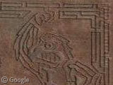
Thanks: Adam Sachs, Brian Messenger & Marc Armstrong
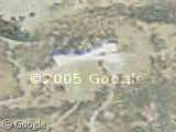
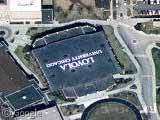
Here is the stadium itself:
View Placemark
The grandstands are empty, but the adjacent parking lots are filled. That leads me to believe that the picture was not taken on a Saturday game day, but rather on a weekday when the university is in session. Stadium parking areas most likely are used for overflow parking during the week.
There was no game that day, there was a huuuge car wash festival lol!!!
The ISU mascot is a cardinal, but also a cyclone, so the logo is a sort of cycloning cardinal.
I already submitted the stadium, I think the spine of the practice facitily looks really neat next to it.
Stadium parking isn’t really a daily overflow, it’s where everyone that lives in Friley parks at. During the school year it’s full all week and then partly empties on the weekends when people leave or can park on campus legally. It completely empties on the night before a game day, or you get towed, as I did. Stupid football games.
The first look, I thought it was an RFID chip! hehe
Off topic… I hope you don’t mind. I linked your site and wrote a short blurb.
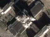
Hey, look what I found… View Placemark It’s a big parking lot, way west of corn maze, that seems to be adjacent to some giant blurry thing. It looks like the building picked up an invisibilty pack from Halo or something.
“Hey, look what I found… View Placemark It’s a big parking lot, way west of corn maze, that seems to be adjacent to some giant blurry thing. It looks like the building picked up an invisibilty pack from Halo or something.”
It looks as if the parking lot serves the collection of buildings across the street. A few of those buildings seem quite tall, from the shadows. I suspect they’re apartments for college students, being fairly close to the ISU campus. The lower square buildings aren’t apartments – a residential building cannot have as wide a “footprint” because almost every room has to have a window – but they could be dining halls or student unions, something like that.
View Placemark
Those are the 4 towers: Knapp, Storms, Wallace and Wilson with their two dinning halls. I use to live in them, but now they are scheduled for demolition. I remember hearing that they leaned so much that architecture students on the top floors had a hard time building their projects level, and that the toilets would slosh back and forth in windy day. I don’t know how they are going to take them down, the implosion would release a giant cloud of asbestos. (Edit: actually, it looks like they destroyed them 10 days ago http://en.wikipedia.org/wiki/Iowa_State_University)
View Placemark
Friley, on the other hand, is the U.S.’s second longest dormitory (behind Westpoint’s) and has it’s own zip code.
Oh, and by the way, it isn’t pronounced “Iowa Universityâ€?. The hawks are the “University of Iowaâ€? and the cyclones are “Iowa State Universityâ€?
Just to clear up the parking issue: When I was at ISU (1999-2003) Residents of Friley/Helser (or whatever it is now) and Birch-Welch-Roberts are required to park their cars next to the stadium in the lots just to the south and east. The bigger lot to the north is for commuter parking. The cars parked there are for students who live out of town and take the bus into campus.
Also note the line of yellow squares in the middle of the lot – those are tents for pre-game tailgating parties/stands.
I never knew there was a corn maze over there. Crazy.