Arecibo Radio Telescope
Thursday, 4th August 2005 by Alex Turnbull
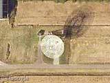
Well here it is, the one that literally hundreds of you have submitted over the past few months. We held off posting it because it would be so much better to see this is high-res. However here it is (finally), the Arecibo radio telescope in Arecibo, Puerto Rico. It is officially the largest single-dish radio telescope ever built; it's 305 metres in diameter, 50 metres deep, and it covers an area of roughly 73,000 square metres! Wow, huge.
You may recognise the telescope from somewhere... this is the where they collect the data for SETI@home, it was in Contact and it was also used as Alec Trevelyan's antenna in GoldenEye!
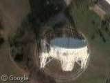
To make up for the poor resolution on this entry, here's a super high-res aerial shot for you to investigate. The official site has loads of great images too, and the Wikipedia entry has all the facts and figures you could ever desire.
Apparently any person in the world may use the telescope, providing their proposal is selected by a review committee. Any ideas for how we might put it to good use?

Juan Cabanela might have been the very first person to send us this, so he's getting the credit! Thanks to all of you who submitted it though.
About the author
Alex has decided that his title will be Senior Vice President of Stuff.

Hi Alex,
A minor correction; The Arecibo Radio Telescope is the not the “world’s largest radio telescope”, but the “worlds’ largest single-dish radio telescope”.
The credit for the “world’s largest radio telescope” goes to India’s GMRT (which is multi-dish) which is situated in Narayangaon, Pune (my hometown B) ).
http://en.wikipedia.org/wiki/Giant_Meterwave_Radio_Telescope_(GMRT)
http://www.ncra.tifr.res.in/ncra_hpage/gmrt/gmrtvisit.html
Regards, Ashutosh
We held off posting it because it would be so much better to see this is high-res. Are updates to the maps frequent?
Ahhh, I feel complet now… thanks
Thanks for pointing that out Ashutosh, somehow ‘-dish’ got edited out of my post along the way. Fixed now 🙂
You guys should make an image overlay for this. I made one but I’m unsure as to the best way to upload it.
Arnaud – it would seem so. The eastern side of Puerto Rico now has high resolution images where it previously did not. It’s probably just a matter of time before more of P.R. is covered.
In the mean time, here’s a shot I took of the upper portion of the observatory when I visited there last year:
http://atpm.com/10.05/puerto-rico/arecibo-observatory.shtml
Lee: that’s the western side! Interesting that there are no major cities in that region of P.R. – so why the hi-res?
Wouldn’t remember what side it was on…all I remember is that it was taken from the visitor platform.
As for the hi-res…I’m not sure I understand what you’re asking. e.g. why NOT hi-res?
I have many other shots of the dish, including a very hi-res image that combined two shots into a vertical panorama showing the receiver assembly and the dish. These shots are on my personal photo album served on home bandwidth. I daren’t link it for fear of getting swamped with hits. My bandwidth can’t handle it.
its interesting to see the map or hybrid view and see the road that goes all the way around the dish. i’m getting car sick just thinking of driving around it.. 🙂
Lee: I was referring to the hi-res images of P.R. not the dish. The eastern end of the island is much more populated (San Juan in particular) and is the only part that I have visited. I would like to visit again via Google Maps.
et phone home
Pierre – oh yeah, sorry. And I did, indeed, mean the western side. My mistake.
As for why there and not, say, San Juan area….haven’t a clue.
As dude says above, how about making an image overlay with the nice high-res official photo? Or could that be infringing copyright?
Don’t talk about India’s GMRT without posting a google map link do it
I don’t know when it happened, but the telescope now has hi-res imagery in Google Maps!
The map was updated a long time ago, but now there’s a 3D model and everything. Look it up one more time, please.