Katrina Map Updates
Saturday, 3rd September 2005 by James Turnbull
The Google Maps and Google Earth data has recently been updated with photos of New Orleans taken on August 31st at 10am and showing the extent of the damage to the city and flooding that was brought by Hurricane Katrina.
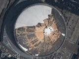
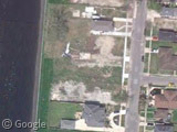
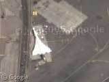
The most striking image is the extent of the damage to the Superdome, click on 'Satellite' to see the "before" shot. Here's one of the breaches in the levee which has flooded the city, including Highway 610 where you can see the abandoned cars. There's boats scattered all over the place from this harbour and light planes that have been thrown around at the Lakefront Airport.
Google hope that the imagery will be used in the development of relief websites but if seeing the damage has moved you enough to want to help then the Red Cross are looking for donations and volunteers.
Thanks: Luke Sleeman

Yah, I do love the overlays. These images are just truly amazing. I have had the one of the superdome as my background for a few days now and I am still in awe. The destruction is just incredible.
By the way, check out http://www.scipionus.com/ for google maps intergration for providing people with information on the city.
I think this is the location of the second breach, which was afaik fixed today by blocking the canal from the bridge to the north: View Placemark
hmm…it would be more useful logistically if they also put hybrid overlay over the katrina shot. So then they culd see street names and all.
Why must you politicize this website? Can’t you stick to its original purpose and keep the political crap on the discussion boards?
Well said Edvado, comments deleted. Take it elsewhere.
the superdome looks like a doorknob
the doorway to hell.
Highway 610 that is linked in the article is actually the interchange between Interstate 10 and Interstate 610. As previously noted on the site, Interstate 10 was heavily damaged where it spans Lake Ponchatrain to the east of New Orleans. The damage reminds me of the damage to Interstate 10 during last year’s Hurricane Ivan.
I wonder why New Orleans spent a couple of days checking people into the Superdome instead of putting some of them on these buses (or these buses) and driving them out?
Not that I’m in any position to secondguess, I’m sure there was some kind of logic to it… I was just wondering…
Hey, does anyone have family/friends down there?
I was wrong on the second buses link, they look like delivery vans in Google Earth. Incidentally, is there any way to view the August 31 imagery in Google Earth?
I’m glad Google did this – I was thinking about it, and one thing that I hope this site does is give those who evacuated a chance to find their house and get a rough idea of the situation to expect… I don’t know about anybody else, but I think if it were me I’d rather give myself a chance to mentally prepare for what may or may not be lost instead of not knowing at all until I saw it in person.
Everyone here probably already noticed, but in case not…
I just noticed that if you hit the “Satellite” or “Hybrid” button, it will show you what it looks like pre-Hurricane. Then if you hit the “Katrina” button, it reverts back to what it looks like after Katrina. Good for showing the difference.
Regarding the buses, it looks as if they’re all flooded as well… maybe they were all undrivable…