Outback Oasis
Monday, 7th November 2005 by Alex Turnbull
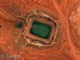
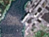
Somewhere in the Australian outback, someone has built an odd little oasis. Why on earth have they done this? Where does the water come from? How do they stop it from drying up? Who built it? Most importantly, why am I asking all these questions?
Thanks to Stiv Rot.
About the author
Alex has decided that his title will be Senior Vice President of Stuff.
I don’t know the answer to any of your questions, but there’s another similar one here, slightly south of the first one.
(Does html work in these comments? we’ll find out)
And waht looks like a dried out version of the same thing here
(Answer: yup!)
Good find, Stridey. They’re scattered all over the place, and these two are dried up.
http://tinyurl.com/bfxxf http://tinyurl.com/aumay
got me… There seems to be nothing but dirt roads and two-tracks out here.
Stridey keeps beating me to it, but maybe this place can offer some clues? Some kind of complex near by.
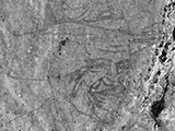
This interesting structure (View Placemark) is located a few miles north – northeast of the original site posted in this thread. Is it a pyramid? I think it is a structure, rather than a design on the ground but I am not 100% certain due to lack of shadows.
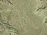
Also, as you move to the south, you find several more oases, including this one that appears to be almost at the center of some sort of blast pattern (View Placemark) — perhaps an old meteorite impact?
The pyramid looks like just another ditch to me, except this time a pyramid-shaped hole has been cut into the ground–an “inverted pyramid”, if you will. The overhead view can be deceiving. I think the strongest evidence for the “inverted pyramid” is the splotch of grey near the center. Some kind of sediment or water has collected at the bottom of this ditch, and since dried up.
As for the “meterorite impact” crater, I think the lines we’re seeing may be drainage pathways down a slope which may have formed when the water spilled over the edge of this thing. Or, it could be the other way around: the ditch is dug at the bottom of a larger depression, and these lines are from percipitation running down the edges and into the ditch.
Either way, they’re still bizarre and definitely seem pointless. I’m guessing they serve the needs of these various “complexes” scattered around the desert (note all the activity around this ditch and a similar set of buildings here.)
Any ideas?
Apologies for the multiple posts. This one is in the middle of an agricultural area very far south of the ones we originally saw. I have a feeling they’re simply watering holes for basic water needs and/or irrigation. Some of them appear to be near mining or excavation areas, and they could provide water to the workers who are far from water sources or they could help with the excation process in some way. The ones near agriculture could help water the fields and serve the needs of the people.
The one’s in the middle of the desert might be there in case of future development or just for emergency. Many of them are dried up anyway and seem to be serving no purpose, but they may have been filled years ago (or they may fill up during certain seasons only).
Just conjecture, but it seems likely.
The green color of the water leads me to believe it may be a strip-mining operation. I say that based not on scientific knowledge, but based on the fact that the strip-mines I’ve seen that fill with water tend to get that strange coloration, possibly from the ores they are digging for?
Guys,
These are basically watering holes for agriculture – mostly cattle and sheep farms in that part of Australia.
The water in a large part of outback Australia comes from artesian basins (underground water supply) that cover a large part of underground Australia in the eastern half.
These dams however are just outside the main artesian supply, so probably depend on rainfall for their supply. Lots of drought in the last few years, hence the ’emptiness’ of some of them!
It seems likely that these are what we rural folk in Canada call “dug-outs”. As noted, just a hole that taps into underground aquifiers and stays full for many years, providing water to livestock and a home for fish and waterfowl.
This is definately a watering hole for livestock. These are common throughout the Australian outback and are usually filled with bore water. The shadow to the left of the water is probably that of a windmill used to pump the water out of the ground.
Yeah, they definately look like dams, fed from the artesian basin. Its amazing how stunning the australian outback can look though.
Hey, this look like an old dirt runway: View Placemark
Here is one View Placemark
oops wrong one View Placemark
Heh
The lines that Michael describe as blast pattern are only the eroded cattle paths going to the water day by day in a high number.
View Placemark
yep, those are what we call “tanks” in texas. you find them on the ranch for livestock to drink from. usually one side is a dam, and rainwater fills it.
definately stock ponds here’s a pic of a small one http://www.ottophoto.com/australia/sa/POND.jpg water supplied by well, not drainage, thats why you see a dam on all four sides
here’s what one in West Texas looks like View Placemark
the lines are sheep trails