The Dames Point Bridge
Tuesday, 10th January 2006 by Alex Turnbull
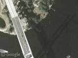
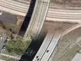
It's been a while since we had a good bridge shadow, so here is the Napoleon Bonaparte Broward bridge - more commonly known as the Dames Point bridge, in Jacksonville, Florida. Opened in 1989, the 2 mile long bridge is the longest concrete cable-stayed bridge in the United States. I think it's also a rather beautiful contruction. Well, you know... for a bridge.
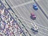
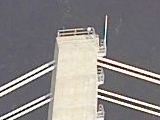
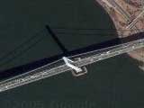
Live Local has some incredibly high resolution imagery of the bridge - detailed enough to make out which models of car are driving across I'm sure. Our other Live Local thumbnail is of the very top of one of the tower verticals, where you can see a 15 foot wide platform and the stairs leading up to it.
Impressive stuff, however I'm still not sure about Live Local - I find the interface for the bird's eye images clunky and confusing. More importantly, I think Microsoft are missing the point slightly, as one of the reasons I like satellite maps is the geek factor - they're pictures, **taken by satellites***, I mean, that's just cool, right?
Thanks to David Fletcher.
* Yes, I'm fully aware that some of Google's best imagery is aerial photography, but that's not the point!

Check this out. Scroll east to the mouth of the St Johns River. There you will see mayport naval Station and an aircraft carrier, the USS John F. Kennedy.
View Placemark
That’s not the cool part. Now, go check out that carrier in Google Earth. There is a jet ON THE FLIGHT DECK! Awesome!!!
There’s no denying that Live Local gets some great images with the bird’s eye feature… but what is with the inability to scroll around? You have to click a thumbnail to get the next view… if you’re looking at something like a neighborhood, it’s too easy to lose your place. I love the clear images, but damn, that thumbnail thing sucks.
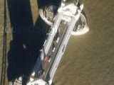
What’s up with the larger of the two boats approaching the north end of the bridge; the one with the bizarre-looking wake. Is it discharging something, is the pilot drunk, or is there a more logical explanation?
@timhogs: Looks like some kind of dredging operation to me – which kind of makes sense that close to the bridge piers and the river bank.
What’s this thing being moved in the water just to the east of the bridge?View Placemark
The bird’s-eye images are taken at a fairly low angle, which means it’s impossible to stitch them together for seamless scrolling The high-res aerial shots in Google Maps are orthophotos, which are taken vertically and adjusted to map precisely to objects on the ground (including, I believe, adjusting for the earth’s curvature).
The thing that annoys me about the bird’s-eye images is that there are a lot of holes in the coverage of a given area, and in some places the thumbnails point to the wrong image.
“More importantly, I think Microsoft are missing the point slightly, as one of the reasons I like satellite maps is the geek factor”
I think we get the geek factor of Satellite maps pretty well. Tom Barclay has been serving free Satellite and aerial maps for years for free at http://terraserver-usa.com/ Tom is now working on Windows Live Local. Our users keep telling us they want better and better quality imagery, and Satellites just simply can’t capture imagery at the resolution, fidelity and angle that can be achieved from an orbiting Satellite. As has already been pointed out on this thread, a lot of the imagery that you see on google local and live local that is often referred to as ‘Satellite’ is actually taken from planes – just at a much higher elevation than the 2000 feet used to capture Birds Eye images. But here’s the rub – no one really cares how an image was captured. they care about what they can do with the image and how it looks. An image of my roof at 90 degrees from Space isn’t as useful as the image captured at 45 degrees from 2k feet.
Coincidentally, i posted some related info yesterday on the VE blog at http://spaces.msn.com/members/virtualEarth/Blog/cns!1p1jUqsfPsDJ0sEPuZ997-OA!436.entry
D-FENSE!
Now, normally I would be backing google over microsoft any day, but I am very impressed by windows live local. Google has nothing that can match the birds eye images. Where else can you see things like this:
http://local.live.com/default.aspx?v=2&cp=40.764389~-74.00077&style=o&lvl=2&scene=329932
I love this bridge.
Look Northeast of the bridge. Thats thousands of Toyota’s.
There is a lot of dredge activity on the North end of the Bridge as they are expanding the JAXPORT operations in this area