Whipsnade Wild Animal Park
Friday, 3rd February 2006 by Alex Turnbull
This is Whipsnade Wild Animal Park in Bedfordshire, England. Whipsnade is one of Europe's largest wildlife conservation parks - it's home to more than 2,500 animals, many of which are endangered in the wild.
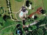
Thanks to Google's new upgraded imagery, several different species of animals can be seen within the grounds. Unfortunately I can't seem to work out what any of them are... even when I compare them to their publicity shots!
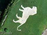
Wait a minute...
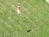
I've got one! I'm pretty sure it's a Lion, right?
Thanks to John and Steve Wrona.
About the author
Alex has decided that his title will be Senior Vice President of Stuff.
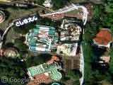

A bit to the north I found this abandoned airport with thousands of cars parked on the runways:
View Placemark
Any idea what it is?
Looks like imported car storage.
thats likely where they stored all of the MG rovers after the company collapsed, and they couldnt find any of the buyers, so there were thousands of cars left unbought.
Based on the Map of the park:
“species” link is a herd of Prezwalski’s Horses.
“animals” link is centered on the Bird Arena with California Sea Lions to the south, the discovery center to the north, and lots of homo sapiens all over the place (especially on the seating around the Bird Arena.
The group of animals in the “several” link is, based on the artwork but not the key of the map, a herd of llamas.
Map: http://static.zsl.org/files/wwap-map082005-95.pdf
Yep, a lion alright.
The airfield is:
http://www.bedfordautodrome.com/
That airport is an amazing find! I’d love to hear more information on it.
Cheers
Woah, no way! I saw this lion a few days ago coming into London on a train, and flying out from Heathrow. Who knew that was actually Whipsnade?
The “abandoned airport” was actually RAE Bedford, later owned by QinetiQ. Wikipedia scratches the history of the place here http://en.wikipedia.org/wiki/RAE_Bedford. The airfield is onyl half of the actual base, the wind tunnel site can be seen a couple of mile south (now partly taken over by the Yarlswood IDC, the one that burned down a few years ago).
At the end of WWII, so many airfields were built in Hertfordshire, Bedfordshire and Cambridgeshire, pilots reckoned you could taxi hundreds of miles from one end to the other without ever having to actually take off.
I just love Google Earth! Nice resolution if you can actually see the animals, except for the lion…:)
Another of the WWII airfields put to alternate use is just outside of Podington, near Rushden, Northants (though it’s actually still in Bedfordshire). View Placemark In 1966 it opened at Santa Pod Raceway and it widely accepted as one of the best drag racing tracks in the world. I could bore for England on the subject (drag racing that is) but I’ll leave you to do your own googling if you’re interested 🙂
We actually have some more info on the Santa Pod Raceway already Andy 🙂