Belfast Docklands
Thursday, 23rd February 2006 by James Turnbull
In our never-ending quest to catalogue everything that stakes its claim to being the "world's largest something" I present to you the world's largest dry dock.
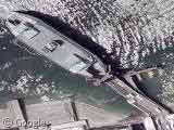
Located in Belfast's Docklands (where the ill-fated RMS Titanic was built) the dry dock is part of the Harland & Wolff Shipyard who also operate the two gigantic yellow cranes, Samson & Goliath. UK readers might recognise the area from a BBC ident that showed skateboarders doing tricks underneath the cranes.

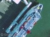
To the west is the ferry terminal where you can see a Stenna Line Ferry which operates between here and Stranraer in Scotland. Submitter Chris had this to say:
This ferry is possibly the Stena Caledonia which crosses in 3 hours 15 minutes. The newer high speed Stena Voyager (HSS) also travels this route taking 105 minutes for the trip.
Thanks: redstar1 & Chris

Nice to see that Belfast has finally been added in Hi-Res!
If you look between the two images above, you find the site where the Titanic was built. Or the remains of it anyway; those two ramps are all that are left of the slipways where Titanic and her sistership Olympic were constructed.
A few frames north-east of the ferry – the shadow of that oil platform is kind of interesting.
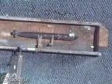
Can anyone identify this interesting looking ship to the north?
View Placemark
It’s the HMS Caroline, a Royal Naval training vessel:
http://www.nhsc.org.uk/index.cfm/event/getVessel/vref/430
http://www.royal-navy.mod.uk/server.php?show=nav.2944
Thanks Tok, That answers my question about the curious looking white structure on the deck. At first look it appeared that they were trying to hide something on the deck under a tent of some sort.
Thanks.
Looks like they caught a nice traffic accident clean-up on the Sydenham Bypass.
View Placemark
My guess is it has something to do with the tractor-trailer parked off to the side off the road just a bit to the north and is a spill of some sort- notice the water trucks washing the road.
Its funny to follow the ‘diversion’ through the suburbs- gridlock!
The oil platform that Timhogs mentioned is the Bulford Dolphin. Picture here.
Go Belfast! Nice to see this city be put on the internet for something other than rioting.