Another Plane in Flight
Monday, 24th April 2006 by
Please note that some or all of the objects mentioned in this post are no longer visible on Google Earth or Google Maps.
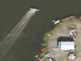
This is a nice high res shot of a plane over autumnal suburbia in Illinois. I can't seem to find the shadow of this one on the ground, but is must be pretty high to appear so big.
Sarah says:
This is a great pic of an airplane, cruising approximately above our house in Palatine, IL.
I'm guessing that you went looking for your house and found this great big plane over the top of it 🙂
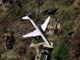
Thanks: Sarah Lopez
That’s almost too simple. I’m guessing they went looking for that plane but noticed the 0.5 pixel wide “FOR SALE” sign in the front yard of the house underneath. Look at the square feet! The gabled roof! The circle drive! The well-manicured lawn and old-growth trees! They didn’t just find a passenger jet — they found a home.
P.S. The large circular purple spot near the tip of the left wing!
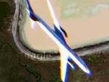
I actually think this is one of the best in flight shots we have seen because of the fact that you can see the windows and the way it is turning. And it looks like it is on the ground!
Here is another one: View Placemark
Ummm… maybe it’s just me, but the Google text ads are totally screwing the comments around into paragraphs of garbled text. Just to let you know. And it’s also overrunning onto the “Leave A Reply” background table image.
No, wait, it’s fixed itself. Sorry ’bout that 🙂
lols, I couldn’t read your comment krebber cos the text was obscured by the leave a reply section…
FYI, it fixes itself on refresh (you’re using firefox on xp I assume). Am looking into a permanent fix now though.
Krebber (or anyone else), I think I’ve fixed the last comment overrunning problem, but I was having difficulty re-creating it very often anyway. If anyone spots it could they let me know please? Thanks 🙂
Im having a similar problem on Camino (ie: firefox engine) on Mac OSX fyi. 🙂
thanks rob, I’ll take a look in camino at home tonight.
Also, is it possible to work out the height of the plane based on the planes dimensions compared to the roads dimensions?
It’d be possible if you could figure out what kind of plane it was. He’s probably low enough that the parallax isn’t much, though. If you scroll in the direction the plan’es going about 12 miles (or just zoom out a few steps), you’ll find… O’Hare Airport.
i’m seeing the garbled up leave a reply thing on firefox on xp. but i refershed it so its ok now.
about the height of the plane, i’m pretty sure that you need the height of the satelite to figure it out
Fixed the gmaps link to actually centre on the plane….
Thanks to Jonothan for reporting it.
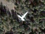
Take a look at these: View Placemark
Shot taken nearby Frankfurt airport. If you’ll zoom out a little you’ll find three aircrafts in a row (actually I think this is some kind of the bug – i.e. same plane was pictured three times)
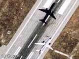
Just about half a mile to the south-east towards O’Hare, here is another plane: View Placemark
>”I can’t seem to find the shadow of this one on the ground, …”
It’s probably on a neighboring image tile.
> “but is must be pretty high to appear so big.”
The size of the plane really has nothing to do with its absolute altitude rather than how close it was to the plane from which the photo was taken. You didn’t think all those crisp photos were taken from a satellite, did you?
Dude!
That’s about 2 miles south of the neighborhood I grew up in. My house was on Coral Reef Way in Lake Zurich!
You can still find this image on google earth in the archive, March 30, 2002. Zoomed and rotated I can almost make out the name of the airline on the side of the plane. I think its Jet Blue, but I’m not 100%.