Stacy Park, Olivette Missouri
Friday, 12th May 2006 by
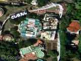
According to Google Maps this is Stacy Park in Olivette. I'm not entirely sure what that huge expanse of concrete is and the 'DANGER KEEP OFF' just adds to the mystery. Surely you can't read that from the ground? Is it a big roof over something? But over what? Do any of our intrepid readers have an ideas?


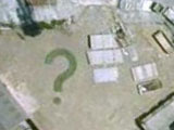
Looks like somebody played a huge game of connect-the-dots on this concrete block…
Being in St Louis (which Olivette is a suburb of) I got a little curious and googled a bit…
Thats the Stacy Park water reservoir as mentioned http://stlouis.missouri.org/government/putilities.html here near the bottom. Also from http://www.olivettemo.com/government/govtgeninfo.htm:
Olivette’s elevation of 700 feet above sea level makes it one of the highest communities in St. Louis County. Since water runs downhill, the City of St. Louis decided this would be the perfect location to build the Stacy Park Water Reservoir in 1926.
…and…
..and finally, this site has the best pics I can find:
http://www.hornershifrin.com/ProjectDesc/stacypark.shtml
They maybe warning helicopters that the roof is not safe for landings.
The concrete is eight slabs held together with seismic dampers and each slab can move. It’s almost certainly not safe for anything to land on.
Wow, mystery solved. Funny there is a little house on it, but you can’t land a helicopter.
Being from St. Louis, I wonder as to why you were traveling to Olivette in the first place. I live maybe twenty miniutes from there and do everything in my power to not go there. Try finding the Budwieser brewery.
BIZARRE! I just flew home and i had a stop in St Louis and I saw this as we flew over and i was going to try to look for it on google but i found this website before i started looking and bam there it is. totally neat.
St. Louis’s Chinatown is in Olivette… What that has to do with this, I don’t know. In fact, that makes me want Dim Sum pretty bad. Mmmm… potstickers