Masaya Volcano, Nicaragua
Tuesday, 20th June 2006 by Alex Turnbull
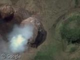
Last year we mentioned that Nicaragua has loads of volcanoes, but that they weren't yet in high-resolution. Since then Nicaragua's most active volcano Masaya, has received fantastic coverage of its multiple nested pit craters Masaya, Santiago, Nindiri and San Pedro (Wikipedia page).
About the author
Alex has decided that his title will be Senior Vice President of Stuff.
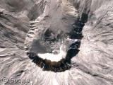

Good craters also covered all Spanish Island of Lanzarote (sadly it is in low-res .. perhaps in google earth)
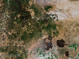
In 1730, the island was hit by a volcanic eruption. The eruption created 32 new volcanoes with a stretch of 18 km. The minister of Yaiza Don Andrés Lorenzo Curbelo which was documented in detail until 1731. The eruption lasted for 2,053 days and ended in 1736. Lava covered a quarter of the island’s surface, including the most fertile soil on the island as well as eleven villages. 100 volcanoes were located in the area called Montañas del Fuego.
Even in Low res is worth seeing.
https://www.googlesightseeing.com/maps?p=&c=&t=k&hl=en&ll=29.012944,-13.552322&z=11
Hey, I like the giant cotton ball! I want to meet it. K, see ya!
hey nice cotton ball its really cool and big and cottoney and and and cool and….. ah cottoney! I could make a bigger one though! But still, cool!
Amio,
That is really cool. look at all of them: https://www.googlesightseeing.com/maps?p=&c=&t=k&hl=en&ll=28.999583,-13.704929&z=13