Mount Bromo and the Mystery Grids
Friday, 23rd June 2006 by Alex Turnbull
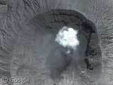
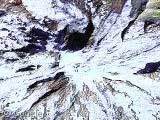
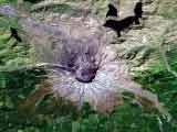
I realise we've had quite a few volcanoes this week, but you guys keep submitting them, so here's just one more. This is the Mount Bromo in the Tenggar caldera, Indonesia, which I think looks fantastic with just one solitary puff of smoke leaking from the crater.
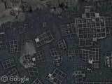
Slightly to the north there's a lake (which could be an old volcano itself I suppose) which has an odd collection of grid-like objects floating on it. Answers on a postcard please...
Thanks to Arthur van Leeuwen, blouet, Asprine, Alastair Dodd and Tggb3k.
About the author
Alex has decided that his title will be Senior Vice President of Stuff.
Giant Shreddies?
They look like blocks used to divert lava flows, they are placed in front of the local housing.
I’m guessing they’re for fishing. Fish farms maybe? No, I’m serious, they could be hatcheries.
No, No, No…
Those objects are… FIRE TRAINING AIRCRAFTS!!! BUHAHAHAHAH
… or children playground?
hmmm… steve, if they need to divert the lava flows wouldn’t they be facing the volcano? i agree with the hatchery theory, there are others in the middle of the lake which vaguely remember this: http://archive.orr.noaa.gov/photos/exxon/06.html
They’re fish farms. If you zoom back, you can see that they are all over this inlet. Fish is a principal part of the diet in this region and it’s doubtful that wild fish can sustain demand. Hence, the farms.
That was fast. I submitted this yesterday, I think I just stole the thunder of a few people that submitted this a long time ago. Oh well, fish farms you say… I’ll allow it
I don’t know about the rest of you guys…..but MY GAWD!!! This new massive Google Maps update is really just overwhelming. I mean, all over Africa, Asia, Australia….SOuth Pacific. Consider my Gob officially Smacked. 🙂
Patrick I feel exactly the same – there is so much new stuff that we pretty much don’t know where to start! I think we still need some time to soak it all in…
No, no, no, they’re fish farms, no doubt.
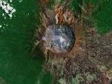
That is totally a cloud…you could probably figure out how high it is from the shadow if you were so inclined. Smoke…any know if there is a site listing active volcanoes?
Alan, I thought it was a cloud too, but it is an active volcano, and this picture convinced me this was actually coming from the volcano! (See the Semeru volcano for another fine example)
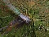
Here’s a list of volcanoes on Wikipedia – most of which have linked lat/longs for easy viewing on your favourite map source.
jammerx is right, they are fish farms. if they where to divert the lava flow, then why would they be in the water? anyway, you can see houses built[presumably on stilts]next to the fish farms: https://www.googlesightseeing.com/maps?p=&c=&t=k&hl=en&ll=-7.727699,113.014174&z=18
Alan, Is this helpfull ?
http://www.geocodezip.com/v2_activeVolcanos.asp
Just Slightly North of the Volcano is a large and very isolated compound. Perhaps a prison because of the double fence around one of the areas. I don’t even see an axcess road. I wonder what that is and why is it so close to an active volcano.
I saw them just now and i’m sure they’re definitely fish farms. Note the southeast in the lake, the same constructions in the water. These on the beach are not used at this moment.
Kirk, the isolated compound is apparently a Hindu temple, check out this photo: http://www-gpi.physik.uni-karlsruhe.de/pub/ego/Indonesien/indo10.html and http://wikitravel.org/en/Mount_Bromo Just slightly to the south of the temple you can see the start of the steep path and on the end is a ledge to look in the caldera.
Theise are fish farms. I’ve visited just to the north of the lake. It gets very cold, and the lake freezes over – hense the white ice! Only half the lake it icy becase there is a picture boundry – one taken in winter, one som other time.
these fish farms look approximately like this: http://www.fao.org/NEWS/FOTOFILE/PH0004-e.htm
No. I’ve visted Mt. Bromo many times. There’s no fish farm in there. I’m pretty sure this is a technical problem during the photographing process. There’s no ice can be formed in Mt. Bromo. The lowest temp could only reach 10C or around 40F.
First of all it gets dang cold at Bromo and this stupid pic is just some retard messing with your mind. Bromo is one of the most amazing places on earth and its like taking a trip to the moon, the sun rise at Bromo should be a wonder of the modern world, but Indo doesnt get the publicity it deserves