Mid-air refuelling
Monday, 26th June 2006 by James Turnbull
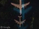
Over a seemingly dull field in California we find an unusual sight - a mid-air refuelling of a C-5 Galaxy by a smaller KC-135! Very, very cool.
The image ghosting is caused by the way satellite photographs are taken in two parts; one is high-resolution, but in black and white, and the other is a lower resolution but captures the colour. The second image is then sharpened with the first to create the colour images we see in Google Earth.
However, in the case of planes in flight, the plane has moved slightly between the two photographs. Now if we just knew how many milliseconds apart the two images are taken you could calculate the speed of the aircraft.
Thanks: Hoppilpolia, rob, chewbaccawokka, Ant, Frank and of course, Helomech from the Google Earth community.

I take my baghdad crash post back, this has got to be the coolest sighting yet….if there was a poll…;)
Very cool.
N Most likely 350-380 depending on losd on C-5. Did you know thar the bow wake on the C-5 will push the C-135 along and make it doubly hard , without lots of practise, to do this. The training for the C-5 and C135R is done at Altus AFB in Altus OK, USA
Excellent find! One plane in flight is cool, two planes flying meters apart (not counting the refueling boom) takes the cake. Any other close formations out there? My dream post would be the full Blue Angels team flying a tight delta formation. The satellite has to get an airshow someday.
You forgot the speed of the plane who take the picture… Impossible to say in what direction he goes.
Phillip, not the blue angels but pretty cool http://local.live.com/default.aspx?v=2&cp=32.776462~-97.440344&style=o&lvl=1&scene=4146283
That’s friggin sweet Dave! When you zoom in you can almost make out the pilot’s helmet. 😀
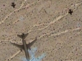
Phillip: I doubt you’ll get much closer than these two gliders.
Dave: That’s very cool! (once I’d copied the link out of safari, loaded up firefox and cursed microsoft – again).
Dave, that beats any sight on this site hands down ever. Sorry, Alex, James and olly, I never thought i would admit that microsoft trumped at something, but if you beat that sight, you will be doing very well.
rob, that (admittedly awesome) Live local pic wasn’t taken by a satellite though was it? So is it really that different from the many other photos just like it?
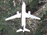
What do people think, is this two planes or just one?
hmm awesome alex, i think that may well be two, cos they are side by side and there is no error on the ground detail, if there was a time delay they would be one in front of the other, otherwise we would have to assume it is strafing sideways.
And murphy, they are done by aerial planes i think, but does not detract from how cool they are.
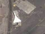
This is a cool formation: View Placemark
Murphy: If I’m not mistaken Google Maps images are taken by aerial planes aswell, not sattelites.
Alex: I would say they are two planes mainly for the same reasons Rob pointed out. Although it looks to me like they are on slightly different trajectories, which is odd.
Rob: Nice find!
Babaganoosh, you are slightly mistaken – some images are indeed from aerial photography (such as the very high resolution Las Vegas ones).
However, this shot is attributed to Digitalglobe, so it comes from the Quickbird satellite which is orbiting the globe at 450km up and is used exclusively for satellite photography.
Oh, sorry. I was under the impresion that all Google Maps images were taken by planes. Thanks for correcting me.
holy crap Phillip, ask and you shall recieve, huh?
No kidding! Thanks for all the links, guys! Now if you guys could just get Google to get hi-res imagery for my area. =) Was the pic of the four F/A-18’s taken with a plane or satellite? I figured since there was one clear image, it was a plane, but I could be wrong.
How did you find that??
Philip: “My dream post would be the full Blue Angels team flying a tight delta formation.”
Well, they’re in a tight (grounded) formation. 😉 View Placemark
Awesome! Did they update El Centro recently? I remember checking before, maybe I just missed them. Thanks for the link, Babaganoosh!
It looks like you worked hard to create this site. Good work.
Kewl picture!
If you know the no of pixels of separation between the panchromatic and multispectral image multiply by 0.6m(spatial resolution) and then divide by 0.2sec ( time between the two images) you will be able to know the speed of the plane.
Cheers Errol
The separation at this resolution is around 24 pixels (as measured in Photoshop), so it works out to 161 mph — which is a bit below the minimum refueling speed (180 mph), so you’re probably right 🙂
BTW http://www.google.com/search?hl=en&q=((24+*+0.6+meters)+/+0.2+sec)+in+mph
I love that this post is now the number one hit on Google for this search, after the conversion of course 😉
Hello
Great book. I just want to say what a fantastic thing you are doing! Good luck!
Bye
Great shot, normal refuel speed for a C-5 is 252 KIAS.