Nazca Lines
Thursday, 29th June 2006 by James Turnbull
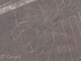
The bizarre Nazca Lines were created thousands of years ago (between 200BC and 600AD) using simple tools to scrape away the dark pebbles and reveal the light sand underneath.
Although they're called the Nazca lines, the famous geoglyphs also feature hummingbirds, spiders, monkeys, and lizards and this giant parrot. But nobody's really sure why the Nazca people went to all this effort - the images are so large that they couldn't have seen them without some sort of aircraft, and that's not very likely as the lines predate manned flight by just a few years.
Apparently for the best view of the lines you need to take a flight over the 53 mile area.
Thanks: too many people to list who submitted this before and after it was high resolution. Thanks all!
I was trying to find them last night and couldn’t! THANK YOU!!
Cocal, a lot of “famous” sites like these are already documented on their Wikipedia pages. – http://en.wikipedia.org/wiki/Nazca_lines#External_links
Not to take anything away from this post, cause it is a really cool site.
what are all the other lines about?
everybody go to you tube and type in yugioh 5ds dark signers this season of yugioh is based on the mysterios nazca lines
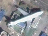
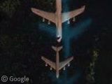
Here’s another plane.
An Amoeba?
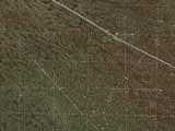
Spiral with lots of other cool stuff below it.
In fact, here’s a kml file with some guesses at where all the geoglyphs are, overlaid onto google maps. Bear in mind that you may have to close some of the info windows to see the geoglyph in question.
Note to self: Implement that kml feature…
I think that spiral is part of the monkey, which can be seen in this [IMG]http://www.mayuc.com/images/nazcaa.jpg[/IMG]arial photo
las lineas de nazca … tienen desde hace tiempo remontable historia aunque no se sabe a ciencia cierta como pudieron ser hechas, pero si quien fue la que cuido las lineas en el largo tiempo… ahora esas lineas estan en mal estado ya que no hay nadie quien las cuide o vigile… que alguien haga algo….
I believe that the Nazca desert was for the Nazca people a huge temple without walls, a pilgrimage center where they used to gather in order to beg their god for water. It was very simple, NO WATER, NO LIFE. I think what ver the reason was, it had to be connected strongly to the liquid element WATER !!!
Cerne Abbas is still discreetly hidden by clouds View Placemark.
See Wikipedia at http://en.wikipedia.org/wiki/Cerne_Abbas_Giant
Hey, this has always been an interesting place to look, go back to the spiral, it’s the tail of a monkey I believe, but if you follow the road to the left a little bit, you’ll see another plane, it’s shadow is almost over the road.
Cerne Abbas wouldn’t be visible anyway since it’s a lower resolution image. However, if you want interesting English stuff, there’s plenty to be seen, look for verious white horses that have been carved into the country side around Avebury Circle. There’s the Alton Barnes Horse, the Cherhill White Horse, and the Devizes Horse. You can also see Stone Henge, Woodhenge, and many others.
The Nazca lines were also featured in the book ‘Evil Star’ written by ‘Anthony Horowitz.
dude I think the nazca lines had sometihing to do with the Aztecs, Inca, myans ect.
Well yeah the spiral is part of a monkey, I have seen this before…
SIGH
I think the Nazca Lines were made by the Nazca Culture between 500 years BC till very likey to 700 years AD. I believe the Nazca people etched the Nazca Lines on the desert to get the attention of their gods, in order to ask for rain.
Maybe ….. Maybe ….. just maybe …
The Nazca Lines were built when people barely even knew animals or insects most of all so how did they put them.Most importanly why and how did they make them so big?
I like the monkey.
There are many mysteries, such as the spider that had a protrusion sticking out of one leg. The spider that they were depicting actually has that (I think its a reproductive thing), but its nearly impossible to see with the naked eye. How did they know the spider had it?
View Placemark
the spiral in the kml that alex posted is not the monkey, the monkey is very faint the center of its tail spiral is here:
anyone else find the planes in the area?
here:
here:
and here:
also some not so ancient glyphs here: