The Great Lakes
Monday, 17th July 2006 by James Turnbull
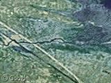
Here's a neat trick - this is a satellite photo of the great lakes, the largest fresh water lakes in the world etc, etc.
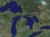
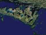
Now if you click to the great lakes and them zoom in step-by-step you'll arrive here:
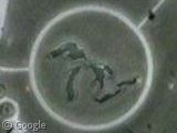
which are the tiny-great lakes! Cool, huh?
Thanks: Tristan
That’s in Sarnia, Ontario, I’ll have to go and check it out in person some day.
If you go north a little, you can see the Blue Water Bridge, which has been in a couple movies.
http://en.wikipedia.org/wiki/Blue_Water_Bridge
That is soooooo post modern!
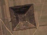
Here you can see another example:
Motorbike Circuit in Cheste (Valencia-Spain)
View Placemark
hehe
Did not work, I get to some intersection…
Yeah, this does not work…. It takes you to the middle of a highway somewhere.
I live about a 2 minute walk away from the MINI great lakes in Sarnia Ontario Canada. It’s just park of a huge park on the bay. To the north is the casino and the twin bridges. To the south is chemical valley which if one of Canada’s main areas for refining oil, including the brand new ethanol plant and a huge coal burning power plant a little further south.
Takuwind – it seems to be working for most people. Zoom in with the slider rather than double click or you’ll lose the centre point!
Go to 48 degrees 58’53.58″ N and 82 degrees 24’48.79″ W It seems to be a berm-type monument or something of the Great Lakes, at a park.