Oil Leaking Ship
Tuesday, 24th October 2006 by James Turnbull
Please note that some or all of the objects mentioned in this post are no longer visible on Google Earth or Google Maps.
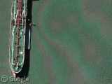
The last time we posted an apparently leaky ship, there was a little debate about whether or not there was oil in the water, but I doubt you can deny that there is certainly a oily haze around this container ship in Galveston Bay, an inlet of the Gulf of Mexico.
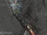
And, it might just be me, but can anyone else see Munch's The Scream in this thumbnail shot?
Thanks: Frank Taylor
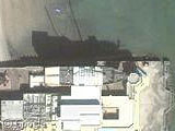
Hmm… I don’t know what’s causing the haze, but I’m skeptical… check out the similar haze about 400m NE. Is the jetty leaking oil too?
I can see Munch’s Scream too! And yes, it definitely looks like there is some oil in the water, but maybe it didn’t leak from that ship and is just floating around.
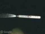
When the film is not perfectly flatted on the scanner glass, those artifacts appear sometimes. It’s called the Newton’s rings : http://www.fas.harvard.edu/~scdiroff/lds/LightOptics/NewtonsRings/NewtonsRings.html
An example of Newton’s rings was featured on this site last year.
In the thumbnail I see The Scream, in the larger photo I see Homer Simpson. He looks mad as though he’s shouting (or perhaps screaming?) at Bart to the left. I also like ducks.
I hate to be difficult, but I agree with nelson. The same phenomenon appears on “both” sides of the levy and is continuous which indicates its on the photo itself and not on the water. I think that the same has happened around the ship.
https://www.googlesightseeing.com/maps?p=&c=&t=k&hl=en&ll=29.331651,-94.776102&z=17
Newton’s rings. End.
PLEASE quit putting the placemark pins directly on top of the subject. All you do is hide the subject behind the pin. Jees we ain’t stoopid. We can find the thing if you just put it close.
@James Bonnette
I don’t see any pins.
I do see a scream. Kinda interesting 😀
Pins?
You can turn your ‘pins’ off James in the toolbar on the left (i presume you are viewing in Google Earth)
what about this ghost ship on the east? https://www.googlesightseeing.com/maps?p=&c=&t=k&hl=en&ll=29.350777,-94.728638&z=17
It can’t be crude oil (the oil mined). First of all, crude oil is a very thick fluid, its color is bromn/grey/black, and you can’t see through it. You wouldn’t see the colour of the sea. Secondly, the only materials that have oilhaze around them, are: aromatic carbohydrates, petrol, diesel-oil, terpentine, kerozene, and some other EXTRACTS of crude oil. SOme kinds of natural and mineral lubricant and cooking oils have it too, in the function of composants. These materials are not so thick, and see through.
AAAAAAAAAAAAAAAAAAAAAAAAAAAAAAAAAAAAAAAAAAAAAAAHHH!!
the Scream ^^
I have been to Galveston, and if it’s not oil/pollution from THIS ship, then it’s from another ship. If you see blue water, don’t be fooled. That’s just a trick of the lens.
I agreen, Newtons rings…But it is a tanker, not a container ship.
Look directly to the east, there’s a submerged ship.
Definitely NOT a submerged ship to the east. That’s an overlay problem.
Why?
1. The boat’s shadow is on the water, not on the seabed.
2. They’d never leave a submerged vessel of that size in the center of that shipping lane. It would cause too much danger to the vessels coming in and out of the ports.
3. It’s actually the boat you see clearly in the photo just a little while after it moved.
See this edited picture to compare the tail ends.
http://www.cycleiwakuni.com/img2.jpg
This is NOT a containership, rather a crude or chemical tanker. Oil does leave a lighter shad sheen, it could be diesel or gas but more than likely it is the picture. Get your facts straight.
It is a problem we come across all the time when scanning aerial film. It is most certainly newtons rings
Um…..First, that’s not a container ship, it’s a tanker.
Second, sorry, “the_d”, but not all crude oils are “very thick fluids” – something like a Kern crude oil (from California) is as black as asphalt, but some crudes look much like a dirty diesel oil, and many crudes have easily enough light ends in them to spread out and form a rainbow on the sea surface. I agree though, that this picture is just Newtons rings from the photo itself.
Richard (Master Mariner, Tankers)
There’s definitely some Munich’s Scream in the pic!
I dunno how to do the placemark thing but check out these co-ords too see a possible oil leak I found. its just out off a shipbreaking yard so I guess its likely , shame its low res
“oil leak” lat=22.2268085242, lon=91.7190172921
GE has been updated and the scene is different.