Helicopter Downwash
Tuesday, 14th November 2006 by Alex Turnbull
Please note that some or all of the objects mentioned in this post are no longer visible on Google Earth or Google Maps.
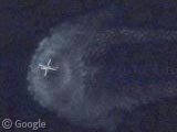
Check out this incredible image of a helicopter skimming the surface of the pacific, several miles off the coast of Baja California Norte, Mexico. How cool is the disturbance in the water from the helicopter's downwash!
About the author
Alex has decided that his title will be Senior Vice President of Stuff.
Interesting!!
Ok seriously, how the hell did you find you?
WOW….GS is now 2 for 2 in incredible posts. What will you do to top yourselves?
It looks like this is still in the US. Right on the border. Probably border patrol…
How very trusting…much more likely drug running.
Probably more like the US Coast Guard doing drills/practice. Their San Diego airbase is just slightly to the north of this near Lindbergh Field. http://www.globalsecurity.org/military/facility/lindbergh-field.htm
This is a U.S. Navy helicopter training area. Just east of here is the Outlaying Landing Field (OLF) for NAS North Island. There is a helicopter conducting a clearing turn on one of the land pads.
Great find…
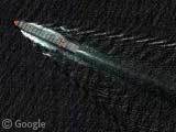
Is this a submarine, sort of due east from the chopper?
https://www.googlesightseeing.com/maps?p=&c=&t=k&hl=en&ll=32.550535,-117.26804&z=18
@Dan: Or a whale?
Or a whale-shaped submarine!
Where is it. I have been trying to find it on google earth for 3 hours now. what are the corditates?
Do you mean my whale submarine, Alex? Didn’t the link take you there?
Interesting – the camera must have a very fast shutter speed to freeze the helicopter rotors like that!
The submarine/whale/shadow: 32°33’0.46″N 117°16’4.86″W