Firefox Crop Circle
Wednesday, 29th November 2006 by Alex Turnbull
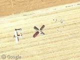
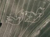
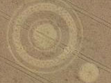
All of a sudden there's an absolutely enormous Firefox Logo Crop Circle carved into this field in Oregon, where previously there was nothing! Are aliens telling us their browser preferences? Or has Internet Explorer finally been eradicated from the Internet?

In fact this 67 metre wide icon was created by the Oregon State University Linux Users Group to celebrate the launch of Firefox version 2, and to the south of the logo you can see that they've also arranged their vehicles spell out "FX2".
You can read more about the project at the Oregon State University site, and congratulations to Jon Hicks - who is now the designer of the world's largest application icon!
About the author
Alex has decided that his title will be Senior Vice President of Stuff.
I wonder what are those people south of the field waiting for? Being kidnapped by open source aliens? 🙂
Oh, I overlooked the FX. If they created this crop circle I wonder how they knew that the satellite was just flying over? Or was this one taken by plane by some Firefox fan at google? ^^
The formation of cars/people/a Piper Pawnee crop-duster aircraft below the logo appear to spell out “FX2” possibly as a reference to the latest version of the popular web browser – FirefoX 2. Slightly too subtle I think, considering the impact of the giant logo.
I never even noticed the FX2!
The photo was actually taken by an aerial photography plane in this case, you can read more about the creation of this logo here and here.
Why is there a completely square shaded box around the logo?
This looks like the source image in the map has been edited in someway.
Anybody else think the same?
Could there be another reason for the different hue and brightness of the shaded box?
Did Google take a new satellite photograph of this map square only?!
Is Firefox hacking Google maps?
Check out: http://www.firefoxflicks.com/web-diaries/?cat=1&paged=2
This will explain the beings which brought this crop circle into being…
It seems very likely that the creators of this crop circle had the aeriel photo taken, which would explain why the photo was taken squarely on the logo. Someone at Google must have come accross the picture and decided to integrate it.
If you view this in real GMaps and zoom in all the way, you will see that the copyright at the bottom changes to say simply Google, and not DigitalGlobe.
View Placemark
i think thats a very cheap way to make comercial. i guess firefox payed google to integrate it. i mean look at the area, there i nothing special on it, just farms. whats so interesting to take a closer look? right, nothing, except u know what u find.
cheers dave
I suspect collusion – it seems that of all the surrounding area, only this one square is available at the highest resolution level.
Yeh, what happened is that basically, someone from google will have been a mate with someone from firefox team, and got given this aerial shot. and just stuck it in the db.
I am the red dot in the “2”, which is not a “2”. We are just laying there. We all sort of plopped down in a random shape. This all happened before firefox2 came out.
the square shape one poster noticed is the ultra high res picture turning into high res picture. The google plane did that because otherwise it would have a line at the low res pictures… they are blending…
rob is not correct… google sent a plane to take the pictures.
Y’know, they should tell us when they’re going to take arial photos… then people all over the photographed area would intentionally make the best sights ever.
On the downside, though, that would open the door to a whole new kind of advertising. Imagine a giant golden arches painted across an entire county, and visible from space, on Google Maps. That would suck.
I’m with Michael (#5)! What in the world is that shadow over the landscape? It appears to be some sort of giant craft hovering above the field and blocking out some of the afternoon sunlight! With full disclosure right around the corner perhaps it won’t seem so strange to think that our interplanetary cousins were also having a quick “look-see” at the lovely human-made crop circle! “Ah Xzeldor, look at what our prodigy can do now! How quaint! They make their Daddy proud.”
On a more serious note, I don’t think it was an accident that the evidence of their admiration was photographed any more than the fact that 2008 was a record year for UFO sightings, with hundreds of satellite images of UFOs being found since the program went live, oftentimes being quietly removed shortly thereafter.
More and more people are coming to the realization that “they” have been taking baby steps for the last 40+ years for their upcoming debut, and it WILL happen, with or without the assistance of government and media. I think it’s unconscientable that their inevitable introduction coincides with Sci Fi TV and movies depicting our intergalactic cousins as scary monsters to be feared with a vengeance.
Think about this: If we ever get beyond our warring status and are able to develop the technology for interstellar travel, the intellect needed to pull off such a feat would not leave room for hate, envy, jealousy, bloodthirsty agression and other low-vibration emotions. On the contrary, they travel in the spirit of universal love and connected consciousness. Imagine the sacrifice and cooperation needed to be traveling so far away from home, and then think about how long their species has been around. As we banter about the very real possibility that we could blow up our own planet with all our nuclear warheads, consider that these creatures must be very far removed from this type of barbarism.
They are truly peaceful brothers and sisters of all living creatures and we need to greet these shy visitors with an open mind and compassionate spirit. What other choice do we have?
who cares if some people don’t use firefox