Australia Day Flyover
Tuesday, 27th February 2007 by James Turnbull
The super-high-resolution aerial images of Sydney from the recent Australia Day flyover have this morning been added to Google Maps.1
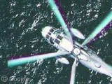
Google even did some sightseeing of their own in the email announcement when they included links to Queenscliff Bay, Shark Bay, Bondi Beach, Manly Beach, Luna Park, a Navy Ship, a Tall Ship, Fort Denison, Circular Quay and a totally awesome Helicopter in flight!
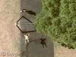
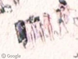
However we refuse to be outdone! So here's some of the best sights we found ourselves, such as a kid on a swing, with a cool shadow...
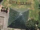
...the words SEX + DEATH formed in grass beside a weird glass pyramid...
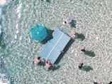
And people playing table tennis. On a floating table tennis table!2
The Australia Day event is different to the rest of Google's aerial photography, as they actually pre-announced when the plane would by flying over, and even provided a tracker so that you could tell exactly when it would be overhead.
As reported by the Sydney Morning Herald, lots of people naturally took the opportunity to do some serious advertising. One local company spent 10,000 AUD on a huge vinyl sign, whilst many others were attempting to promote everything from websites to dating services, and one person in particular even tried to do some promotion for their own political campaign...
It wasn't all rampant capitalism though - one man staged an effort to send a message to his estranged wife, in an attempt to secure a reconciliation via the medium of Google Maps...
However, it would seem that all this effort was in vain, as it was later reported that the plane had taken a different flight path than originally described, and didn't actually arrive at each spot at the planned time, and also didn't cover nearly so much ground.
According to the SMH article:
At Bondi Beach, Erland Howden and a team from the Nature Conservation Council of NSW rallied over 50 troops together to create a human sign that read "Vote Climate''.
So, we scoured the images of Bondi Beach for any signs of a message. We found lots of new entries for our list of the Top 10 Naked People (and we may yet get to have a Top 100 Half-Naked Hot Chicks post!3), but by the time the plane actually arrived all the climate change campaigners had given up and gone home, as apparently they were suffering from sunburn (I'm sure they were well aware of the irony).
Here the story gets suspicious however. Again, from the SMH article:
Michael Fox and his wife Jodie Fox also had a run in with bureaucracy in the Moore Park, near Fox Studios. Using coloured pieces of A4 paper held down with bamboo satay sticks, the couple and a friend had formed the image of a giant eye.
So we located Moore Park on Google Maps, and yet strangely (despite the fact that this is newer imagery than is currently available on Google Earth), there is no giant eye here! In fact, it would appear that despite being newly updated, this image wasn't taken on Australia day at all...
So, after hours of combing through the new images, we've found no real examples of private advertising or even any sign that the people of Sydney knew they'd be on Google Maps!
Well, except this of course...
...but given that australia.com is the official website of the whole country, it can't possibly count as spam, right? If so, does that mean no spam made it through at all? All those folk who spent money on giant banners might be upset, but the Slashdotters would be pleased - they were up in arms about the potential "spamming" of Google Maps.
Some conspiracy theorists may say that the delayed flyover was a last-minute change of heart by Google, who perhaps didn't want their maps application full of free adverts. And whilst it's certainly possible that over the last 4 weeks Google have been going through all the images and replacing any remaining sections containing spam, they did actually promote this event as "get yourself on Google Maps", so they must surely have anticipated what people would do, right?
-
And now also Google Earth. ↩︎
-
Surely a new No.1 for the Top 10 Sports on Google Earth! ↩︎
-
Many apologies to our female readers, we're sure there's some hot dudes down there somewhere too... ↩︎

im disappointed that GSS fans in australia didn’t take the chance to advertise this awesome site.
Just offshore from the australia.com in the sand are lots of surfers. Most are heading out so the good surfing is probably beyond the new shots:
https://www.googlesightseeing.com/maps?p=&c=&t=k&hl=en&ll=-33.893882,151.2756&z=20
A hovercraft?
https://www.googlesightseeing.com/maps?p=&c=&t=k&hl=en&ll=-33.863214,151.253991&z=20
And just south of the hovercraft, near lots of fancy motorboats and sailboats and near fancy houses with built in pools, two guys in a kayak:
https://www.googlesightseeing.com/maps?p=&c=&t=k&hl=en&ll=-33.864726,151.253583&z=21
Place nice kids
https://www.googlesightseeing.com/maps?p=&c=&t=k&hl=en&ll=-33.863718,151.256013&z=22
Tom, I think it’s a catamaran, not a hovercraft. But still cool. 😉
What is that Navy ship? It doesn’t look like anything… normal. Any answers?
Also, this is dodgy-image-sticking-together-ness.
This looks painted on: https://www.googlesightseeing.com/maps?p=&c=&t=k&hl=en&ll=-33.864286,151.250245&z=22
Hmmm….. Spooky – https://www.googlesightseeing.com/maps?p=&c=&t=k&hl=en&ll=-33.865352,151.254671&z=20
There’s something very odd going on with this boat!
I just did some research about the Navy ship.
It’s an Amphibious Transport Ship of the Royal Australian Navy: http://www.navy.gov.au/fleet/amphib.html (Correct me if I’m wrong) They have 2 of these Ships: HMAS Manoora and HMAS Kanimbla. Who can find out which one it is? Check out the ships’ image galleries for photos!
It’s not a weird glass pyramid, it’s just a glasshouse in a botanical garden (nice glasshouse I must say…)
There’s no advertising because Google screwed up the plane – they assumed they’d get flight clearance, but didn’t, so they weren’t able to be in most of the advertised places at all, and for those places they did get to, they were there hours later – by which time everyone had packed up and gone home.
Details at smh – http://www.smh.com.au/news/web/aerial-photos-put-the-focus-on-sydney/2007/02/28/1172338633620.html
SEX+DEATH is easy to explain: the glass pyramid is the Sydney Tropical Center, located in the Botanic Gardens. SEX+DEATH is an exhibition of carnivorous plants + orchids that’s on at the moment: http://www.rbgsyd.nsw.gov.au/royal_botanic_gardens/Whats_on/royal_botanic_gardens__and__domain_calendar/event_view?SQ_CALENDAR_VIEW=event&SQ_CALENDAR_EVENT_ID=71007
The cannons are off their mounts. Does this mean peace has broken out?
https://www.googlesightseeing.com/maps?p=&c=&t=k&hl=en&ll=-33.852433,151.246455&z=22
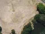
This can’t be a natural formation. The lines are too perfect. I wonder what it is.
https://www.googlesightseeing.com/maps?p=&c=&t=k&hl=en&ll=-33.849825,151.246803&z=22
And just down the shore, someone want to go clean up the old … ummm … pipes?
https://www.googlesightseeing.com/maps?p=&c=&t=k&hl=en&ll=-33.851158,151.246893&z=22
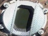
Cool! An open air movie theater! And they put the text on it so that it is right side up for us!
https://www.googlesightseeing.com/maps?p=&c=&t=k&hl=en&ll=-33.861573,151.220894&z=20
The abandoned White Bay Power Station. You can see the smokestacks.
http://en.wikipedia.org/wiki/White_Bay_Power_Station%2C_New_South_Wales
https://www.googlesightseeing.com/maps?p=&c=&t=k&hl=en&ll=-33.866999,151.177336&z=19
There sure are a lot of vans here:
https://www.googlesightseeing.com/maps?p=&c=&t=k&hl=en&ll=-33.861427,151.185774&z=19
And there’s more on the south side of the bay.
Last one… leveling land for home development. Those are pretty cool looking rotary saw vehicles. I have the handheld version.
https://www.googlesightseeing.com/maps?p=&c=&t=k&hl=en&ll=-33.802142,151.295565&z=21
I like these surfers, all trying to catch the wave it seems:
https://www.googlesightseeing.com/maps?p=&c=&t=k&hl=en&ll=-33.891649,151.280079&z=20
Here’s some people learning to scuba dive…
Scuba diving! That’s great!
Some beach volleyball: https://www.googlesightseeing.com/maps?p=&c=&t=k&hl=en&ll=-33.794565,151.287769&z=21
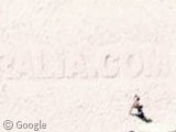
Oh and a bit north of the volleyball, letters in the sand: Australia 2007!
https://www.googlesightseeing.com/maps?p=&c=&t=k&hl=en&ll=-33.789422,151.288237&z=20
The Google flyover was one of the biggest deceiptful acts I know. Google did flyover on Australia day, but the pictures taken are from a completely different day. I emailed google, and funnily enough no response. I have a schedule of ship dockings in Sydney and there was no ship docked at the Overseas Passenger terminal on Australia day!! yet Google claims the pictures are real? come-on fess-up the pictures were taken on a completely different day; that is why there is no advertising. Even if the plane did arrive late (it didn’t) then there would be SOME people with signs… nothing!
“The Google flyover was one of the biggest deceiptful acts I know.”
That might be a little overstating it. It’s not as if Google invaded some foriegn country because they claimed that had WMD or something!
The “Floating Ping Pong Table” features on the australian TV show Bondi Rescue This week (I just saw an add for it, and remember seeing the flyover of it on this site) Just thought I’d share that with you! 🙂
That “big glass pyramid” is actually the Royal Botanic Gardens Tropical Centre.
An interesting postscript to this flyover was an episode of ‘Bondi Rescue’, a TV show detailing the activities of the lifesavers at Bondi Beach. The episode (#5,series 2) this week was shot on Australia day, so many of the sights we see on google maps could be seen in live action.
The lifesavers’ beach shelter: View Placemark (-33.890998,151.278077) and their control room: View Placemark (-33.890575,151.277817) the table tennis game: View Placemark (-33.891565,151.282306) and the surf carnival, with a swim race in progress: View Placemark (-33.891484,151.277604) Actually one of the swim races was dramatically interrupted by a swarm of bluebottles, which forced the closure of the beach for a period.
Bondi is a busy and dangerous beach and as benign as it looks in these photos, there was still plenty of work for the rescuers. It might look calm, but this: View Placemark (-33.892903,151.276339) is a rip in which at least five people were rescued in the course of the episode.
Oh, and if you were following the episode, you ‘d know that somewhere here: View Placemark (-33.891751,151.276267) : is a guy pilfering from purses and bags.
They even took a photo of themselves. Heres the shadow of the google plane:
View Placemark
Here’s the climate change sign we made on bondi beach:
http://www.climatemovement.org.au/content/view/81/378/
From current projections we’ll need lilos to attempt this again in 2100, Bondi beach will be underwater.
Here’s another ad in the sand that says “Australia 2007”
View Placemark
The Table Tennis table wasn’t exactly floating… its just been set up in the water. I guess the guy taking the footage is standing up on the right hand side behind the fence.
http://www.wotnext.com.au/playVideo.asp?page=tags&sortby=&dir=&cat=20&date=&paginate=&id=3993
BTW the shadow of the plane seems to have been edited out.
Does anybody know how the organizers of Australia day knew their was going to be a flyover?
I’m keen to get a group of friends together here in Christchurch, New Zealand to see if we can make some kind of distinguishable shape!
Check out Bondi beach carpark. Half full, on Australia day. In reality, the traffic and parking is shocking.
Tom said “This can’t be a natural formation. The lines are too perfect. I wonder what it is”.
Could of been some foundations for a port. Im pretty sure that headland was used for a hospital and sort of holding place for diseased people coming off incoming boats. Im talking around 200 years ago.
” The abandoned White Bay Power Station. You can see the smokestacks.” Cant believe they are still there.
Cant wait for the next flyover. There normally is massive amounts of events happening, especially in and around the harbour.