National Geographic African Megaflyover Project
Thursday, 8th March 2007 by James Turnbull
News has spread across the internet over the last day or two of a "hack" that allows you much more zooming on Google Maps.
Unfortunately for all the people who've wasted hours scanning the earth, this is really nothing new. There are no methods for seeing higher resolution images of your favourite area than you can see today in Google Maps and Google Earth.
The confusion has developed from the recent Australia flyover and the far-from recent Africa flyover project. The result of both projects was images of a much higher resolution than elsewhere in the world - meaning there's an extra zoom level or two in these areas and these areas only1.
A lot of folk have been suggesting that we feature these "new" sights, and even though we've highlighted a few before I thought I'd have another look...
The 500 different Megaflyover photographs included in Google Maps and Earth were selected by Mike Fay from his library of almost 92,000 images, taken from a small plane flying at low altitude.
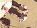
A couple of my favourite images are these guys in a small village, looking up at the aircraft as it passes over...
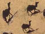
I also liked this pack of camels, roaming the desert.
But there's hundreds more. So please, take my advice: Stop trying to hack URLs, load up Google Earth and switch on the "National Geographic Magazine Layer" under Featured Content. You'll find it much more rewarding.
Previous Megaflyover shots on Google Sightseeing: Victoria Falls, The Longest Conveyor Belt in the World and N’dama Skull and Australia Day shots: Australia Day (check the comments too), NRMA Motorfest ‘07 & Nessie.
Wikipedia Links: Mike Fay and his MegaFlyover
-
It wouldn't make sense to add these extra zoom levels to the other 99.9% of the globe, there would be a whole lot more confusion! ↩︎

I’ve seen t hat camel image before – Snopes.
http://www.snopes.com/photos/animals/camelshadows.asp
Ok, it’s not the same one, but almost. 🙂 If you don’t zoom in, you might think that the black camel shapes ARE the camels. But they’re merely the shadows..
You should definitely visit this article which gives you a link to a Google Earth file showing the locations of some of the best locations of the African photos including those of animals (like elephants, hippos, camels, etc.) all categorized by type:
http://www.gearthblog.com/blog/archives/2006/08/see_african_ani.html
On an unrelated tangent, does anyone know what those annoying spasmatic white shapes are on Google Earth when you first download it?
Clouds?
they’re all the lines radiating from the center in this picture. It seems the only way I can get them to go away, is to turn off the borders. But I need the borders, so that gets me nowhere.
Portland, Oregon goes up to level 20, though the maps.google.com interface only gives you 19. Funny, I could swear it used to go all the way down..
Todd, delete Google Earth and everything associtated with it (like Preferences) and re-install it. This might help. Maybe. Just an idea.
The camels aren’t “roaming” – one of them has a pack on its back. Unless they’re hitch-hiking?
One of the camels has not only a pack on its back. If you look closly, you will see, that there is a person sitting on that camel. https://www.googlesightseeing.com/maps?p=&c=&t=&hl=en&ll=15.294585,20.479863&z=23
men watching to camera in google earth :
http://matiascallone.blogspot.com/2006/11/google-earth-hombres-sonriendo-cmara.html