Image Update March ‘07
Thursday, 29th March 2007 by Alex Turnbull
Yes, another update is upon us!1 Only in Earth at the moment (but sure to appear on Maps very soon) Now in both Earth and Maps, Google has unleashed the following coverage for us to explore:
****New high resolution****
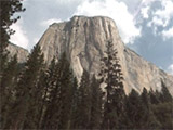
- Canada: Downtown Vancouver, BC
- England: Northamptonshire, Nottinghamshire, Berkshire, Peakdistrict, Birmingham, Greater Manchester, Avon, Gloucestershire, Lincolnshire
- France: Rennes, Poitiers
- US: Omaha, NE; Missoula, MT; Amherst, MA; Keowee, SC; Catawba Wateree, NC/SC; Rolla, MO; Nashville ("Burbia"), TN; Gaston County, NC; Anne Arundel County, Maryland; Metro Water District of Southern California; State of Arkansas
****Updated Imagery****
- Spain: Gran Canaria, Fuerteventura, El Hierro, La Gomera, Tenerife, and Las Palmas (Canary Islands) Spain
- US: Austin, TX; San Bernardino, CA; State of Connecticut, Los Angeles, CA in spots
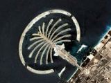
- Australia: Sydney harbour area.
Sadly however, Google have fixed the photoshopped plane formation in Denmark that we posted about a couple of weeks ago -- which is a shame, but doutless the wealth of new stuff will help make us feel better 😉
Thanks to the Google Earth Blog.
-
It was actually only February that we had our last update, so perhaps this is the beginning of more frequent updates? ↩︎
About the author
Alex has decided that his title will be Senior Vice President of Stuff.

Woo Omaha!
Vancouver, you say?
There are some weird ghostly objects on the eastern side of Canada Place (the white building extending into the harbour).
Yes I am glad they updated Gran Canaria, too!
I just wrote on my blog how important it is to use Google Earth to gain trust with your website visitors.
GAH! still no hi-rez for Milwaukee. I want to be able to pick my house out lol
Yippie!!… a long over due Austin update… wait it’s with images just a few months older than the ones before which were 4 years old themselves… eh … at least it’s a little clearer. ehhhh
Yeah, the San Bernardino update is just a few months older as well..late summer ’03 I believe.
I believe that Arundel County is in Maryland – it’s not entirely clear from your list. Or maybe I’m just sleepy.
Yes, Anne Arundel is in Maryland, not California!
I’ve updated the list for clarity — Anne Arundel is now back in Maryland where it belongs!
Still no Canterbury? 🙁
Take a peek at New Orleans. They reverted back to pre-Katrina photos. “Nothing to see here! Please move along…”
vic, the new orleans imagery been like that for months… mid 2006 if I remember correct. The Katrina database is still available, but it’s not accessible from the free client.
Oddly Manchester (UK) is increased in resolution but the images dont seem to be any more recent.
FINALLY!!! Updates for the UK. About time too!
Milan – can you provide a link? I can’t find anything resembling “weird ghostly objects” near Canada Place.
Canada Place
Look at it in Google Maps.
Any reason why they updated Vancouver? Last time I checked it was fairly up to date.
Still no major updates for Croatia…I want my Croatia!! Can’t wait to see the Plitvice Lakes from above…
By the way, Arundel County, MD, has a huge, relatively new mall. It occupied this smallish area in the middle of the woods just south of the BWI airport when it was first built, but since then it’s expanded about as rapidly as DisneyWorld. 🙂
The weird, ghostly objects next to Canada Place (a cruise ship dock) are a product of when the Google Earth people stiched this new high-rez image onto the old images. Since they cropped this new image, there are parts of the old image that are covered up. As a result you can still see the back end of a cruise ship from the old image.
Here’s the old image: View Placemark
Holy wow, I’m from Anne Arundel county MD (Severn, to be specific), and I live in Austin now. Coincidence?
OR DIVINE INTERVENTION?!
dun dun dun
BTW, any other residents of Severn come to this site? Let’s talk about elementary school!
By the way, thats LINCOLNshire. 😉
Thanks Eric, that’ll teach me to trust somebody else’s list! Corrected, cheers. P.S. Updates have now made it to Maps too.
One extra correction, “Berkeshire” should read “Berkshire”. Ta.
The updated images for Vancouver BC are old. There are no signs of RAV line construction on Granville and the Royal Bank is still there, on the north west corner of Cambie and Broadway.
How often do they update the images?
Check out the rotating boat in Sydney Harbour! Looks really cool: View Placemark (33.513609,151.124197)
I’m sorry, the link wasn’t right: View Placemark It’s in Earth and Maps!
Thanks
Nottingshire! Isn’t that Nottinghamshire also?
Pedant
Ah, hum, well spotted Keith. Now fixed 😀
i would like to be a member of google pls.
pls accept me as a friend to google
how to see live image places through google earth
how to use google earth to see live images,anybody can tell me plzzzzzz
Can you update Montgomery Township in New Jersey?
Ooo.Its amazing and i want more update.
why did nobody answer khair ghann ? ? search for google earth and download it.
No wonder we are the most hated on earth. 🙁
I think he wanted to see real time images …. but I agree that’s no reason not to reply.
any 1 c them 2 things in greenland?
may i know if when are you going to upload latest images, because in the Philippines, especially naga city is not clear enough to see the entire field of the city. thank you.
Philip