New Orleans
Thursday, 5th April 2007 by James Turnbull
In case you missed it, there was recently a spot of bother over the New Orleans images in Google Earth. Back in August 2005, just after Hurricane Katrina wrecked the city, Google updated Maps and Earth with images of the devastation.
Then, in September of 2006, the images were updated with higher-resolution shots of the city - images which were pre-Katrina. Nobody really noticed until the March 2007 image update, and suddenly everyone was up in arms over Google's disrespect for those who suffered. In response Google provided new, high resolution, post-Katrina images of New Orleans.
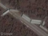
Outside the newly updated area you can still see some of the devastation Katrina wrought here, like this derailed train, or these flattened houses just over the border in Mississippi.
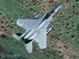
Inside the updated area however, the images are very high quality, and the first thing that caught our eye was this fantastic shot of an F-15 fighter coming in to land at the New Orleans Naval Air Station.
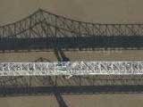
We also wondered what was going on on the Bonne Carre Spillway Bridge?
Thanks: 2468Scotty and C.P. McDill.
Wow.
That’s the Bonne Carre Spillway Bridge.
The Atchafalaya is west, between Baton Rouge and Lafayette.
Although, you’ll see that on either bridge, just about everyday…
Bombs or Fuel Tanks?
Ethan’s right. The Atchafalaya Freeway is here:
https://www.googlesightseeing.com/maps?p=&c=&t=k&hl=en&ll=30.355398,-91.641769&z=13
(no high-rez, sorry)
I think those are external fuel tanks… I think dummy bombs are still put away inside when not used. but don’t quote me on that one…
I am pretty sure these are external fuel tanks, probably out of use.
Yeah, I doubted that they’d leave any sort of ammunition outside. Just the finned tanks/bombs are arranged a lot neater than the unfinned one, suggesting they might be dummy missiles or something.
Wikipedia has the answers!
The finned tanks are for the F-16s at the base, the unfinned ones are for the F15s. Problem solved.
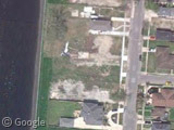
What’s the significance of all the blue roofs in the New Orleans neighborhoods? Is this a particular type of roof common to the area (either pre- or post-Katrina), or is it some marking related to the recovery, or just some artifact of the images?
The blue roofs are FEMA tarps. They’re to patch holes in roofs from the storm. A lot of them are still there.
Look like blue tarps.
That fighter jet has to come into the top 10 google maps spots on google sightseeing, surely?
@Ethan, thanks for the correction.
https://www.googlesightseeing.com/maps?p=&c=&t=k&hl=en&ll=29.971633,-90.021383&z=18
thats where the levee broke.
and here’s a personal photo
http://www.facebook.com/p.php?i=2718522&k=f44ab8761a&r
of this:
https://www.googlesightseeing.com/maps?p=&c=&t=k&hl=en&ll=29.967625,-90.021511&z=19
Facebook. Meh. Why do people have this insatiable urge to post links that lots of people are theoretically invited to see, but the link requires a registration?
I totally agree. FB, Twitter, myspace……. yawn.
Doesn’t this F-15 looked Photoshoped to you? Shouldn’t it cast a shadow somewhere on the ground? I looked around but couldn’t find one.
Wow it’s pretty immence to see the state of the devastation first hand like this.
sry bout that, they advertise it like you can share it for free and i was lazy to find other hosting, but now i did.
on new hosting
Randall – thanks for uploading the image to a more-public place. However, if you’d like to host it somewhere a bit more permanent, I see that this page is without any illustrations: http://en.wikipedia.org/wiki/Urban_search_and_rescue#The_FEMA_marking_system
That would be quite helpful. I’d upload it myself, but I think you have to let them know you’re the real copyright holder …
i have better photos of that X, check back to that page and you’ll seen what i mean
There’s a high res shot of an American Airlines jet in flight over the lake. Maps
Raoul: the shadow of an F-15 usually arrives a couples of minutes later ;-).
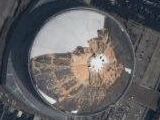
The proof of the Date of the images is in the superdome
https://www.googlesightseeing.com/maps?p=&c=&t=k&hl=en&ll=29.95149,-90.081971&z=19
A thought for Edinburgh: in Plus, we can switch in and out our private overlays. Would it be possible to include historic imaging to provide before-and-after, to such extent that such images may be available?
Thank You
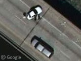
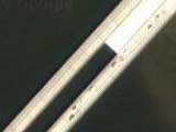
The car is blocking the road because there’s there’s something on the road ahead (probably fallen of a truck standing close to it)
F-15 (USAF) is landing to NAS New Orleans and there is another F-15 in the base! Also there are navys F-18 Hornets.