8 More US Street View Cities
Wednesday, 12th December 2007 by Alex Turnbull
The Google latlong blog has just announced that they've added street view imagery for 8 more US cities - Boston, Dallas, Fort Worth, Indianapolis, Minneapolis, St. Paul, Detroit, and Providence.
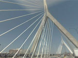
They've also linked to this cool image of the Zakim Bunker Hill Bridge in Boston for us - but what new activities can you find on the streets of these cities?
Just remember to send us your finds!
Thanks to Rob for letting us know.
About the author
Alex has decided that his title will be Senior Vice President of Stuff.

There seems to be a much greater coverage now, than in the older covered cities. Dallas and Fort Worth for instance has a huge amount. Boston also is good, as there is the red sox stadium and harvard university.
They apparently didn’t care too much when they were covering the freeway north of Boston, just do it at night why don’t you. View Placemark,,0,-0.45288271426993437&ll=42.858853,-70.91589&spn=0.063797,0.128574&z=13
Go to Dealey Plaza (http://maps.google.com/maps?output=setprefs&near=Dealey+Plaza,+101+S+Houston+St,+Dallas,+TX) and you can see the spot where President Kennedy was assassinated. (There’s a “X” in the road.)
All I can say is Cheers
Good catch mrb! Love it.
And Kennedy was shot from this window:
View Placemark,,1,-11.627046198595007&ll=32.793552,-96.80603&spn=0.028356,0.080252&z=14
Although not everyone will agree with me! 😀
They also mapped many smaller towns in Indiana: Lafayette, Bloomington, Fort Wayne, Kokomo, Danville, South Bend, and so on.
Still no Washington, huh? Hmm.
there’s some very long countryside drives available around Minneapolis.
View Placemark
Now how hard would it be to add some cars and a games engine and make the most realistic driving game ever made?
Looks like the countryside drives around Minneapolis are the donut cutting capitol of the world: http://maps.google.com/maps/mm?f=q&hl=en&geocode=&time=&date=&ttype=&q=dealy+plaza,+dallas,+texas&ie=UTF8&ll=44.478748,-93.072395&spn=0.053402,0.173035&z=13&om=1&layer=c&cbll=44.449227,-93.080156&cbp=2,347.75282791342056,,0,23.558277418893965
Hmmmm see if the link works better now … View Placemark,,0,15.036619420422271
Both worked fine for me Tammo – awesome find! Brruuuumm! Brum! Brum!
Here’s a view from the deck of the I-35 bridge in Minneapolis before it collapsed.
You can see workers refurbishing the bridge:
View Placemark
Wonder if this is ‘9th & Hennepin’ …. as in the song by Tom Waits? View Placemark http://www.lyricsfreak.com/t/tom+waits/9th+amp+hennepin_10233829.html
Seems I got the link wrong AGAIN … Duh!
View Placemark,,0,0.4551157341484061
The 9th and Hennepin from the Tom Waits song is here:
View Placemark,,0,0.4551157341484061&ll=44.982285,-93.270278&spn=0.021249,0.043645&z=15