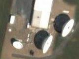
Mystery Military Satellite Calibration Test Card?
Wednesday, 19th March 2008 by Alex Turnbull
Alan Turnbull (no relation) contacted us to tell us about his bizarre find at RAF Feltwell in Norfolk, England, which at first glance looks like it might be the world's most complicated sports pitch.
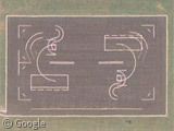
But what is it really? RAF Feltwell is currently used by the United States Air Forces Europe, and Alan suggests that this could be some sort of satellite calibration test card for the US 'Son of Star Wars' missile defence programme!
Naturally a MoD spokesperson quoted in The Metro newspaper suggested that this is simply a "motorcycle range"1, but interestingly there are another two of them side by side at the absolutely massive US Naval Station Norfolk, Virginia2.
Alan's website has more details on various crazy conspiracy theories, and the Metro went with the "proof of aliens" headline - so we're left without a definitive answer so far. What do you think these things are for?
-
Whatever that is. ↩︎
-
It's the world's largest Naval Station in fact, occupying 17 square kilometres. ↩︎
About the author
Alex has decided that his title will be Senior Vice President of Stuff.
I thought this seemed familiar. The Metro does come up with strange stories though.
I’m going with the crazy sport pitch idea.
Motorcycle range. That is the best explanation the military can come up with?
The one in England and the right-hand one in Virginia are exactly the same and are exactly the same size.
Maybe it’s a conspiracy related to places named Norfolk–if someone can locate one if these in Norfolk, Mass. or Norfolk, Conn., then maybe we’re onto something!
This may be used for satellite or for alien communication, but my motorcycle class and I used it to learn the rules of the road. The larger ( ) looking lines are used for driving around to learn throttle control. The smaller (( are used to learn to brake in a turn or to accelerate in a turn. The straight lines are used to test your ability to drive in straight line. I didn’t remember the boxes, but we did line our bikes up side by side where they are now. Once we became familiar driving around painted lines, the instructor used cones to make it more difficult. There are two in Norfolk because Virginia has a 1 to 1 1/2 year waiting period for the class. This was my experience, but others may know that the Scientologists or NASA is working in cahoots with the Motorcycle Safety Foundation to communicate with other galaxies…..
Rock’s story is convincing. I was going to guess that large semi-circles would be good calibration for satellite imagery because the curvature would change depending on the altitude and angle that the satellite is viewing from.
Yea. This is a motorcycle range. Used in training new motorcycle riders. You can see the details of these at the Motorcycle Safety Foundations’ website.
The Range Layout and Diagrams are at: http://www.msf-usa.org/index_new.cfm?pagename=RiderCoach%20Info&content=47B1FBEE-A0CC-53D5-645AD99FDBD901DA&referer=MSTS
If that field in England is in use by the US Air Force, they for sure should camouflage their tents a bit better: https://www.googlesightseeing.com/maps?p=&c=&t=h&hl=en&ll=52.480147,0.517656&z=18
Also, I don’t see how you could calibrate your satellite sensors on something like this – the pitch in Norfolk is even partly covered by shadows.
So maybe that about the aliens is also not true, then?
“What’s a motorcycle range?” you ask. Well, that’s easy. It’s where motorcycles are grown. These happen to be where free-range motorcycles are cultivated; notice there are no pens.
There’s another one at Hudson Valley Community College in Troy, New York.
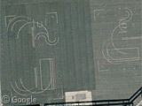
The motorcycle range shares space with a parking lot, so the two sets of lines are superimposed. Still you can make out the motorcyclists’ lines:
View Placemark
Found one at NAS Brunswick in Maine: View Placemark
Even though Dr. R has confirmed that it is a motorcycle training course, it’s kind of strange that these keep popping up at air bases, no? Also the one at Brunswick is literally at the end of a runway despite the availability of free land not by the runway.
Also, next to the course at Brunswick is a symbol I saw before while looking for one of these courses at Naval Base Bangor in Washington state: a flat-ended Maltese Cross in a square. Anyone know what that’s for?
Here’s another one at Ft. Devens, where the MA state police and state motorcycle schools do their motorcycle training: https://www.googlesightseeing.com/maps?p=&c=&t=k&hl=en&ll=42.57726,-71.606784&z=18
These are typical aerial photography (not just satellite) calibration targets.
Interesting PDF package from NASA discussing these used for IKONOS satellites here.
On the bases we used the courses for remote control car courses when the MC tests weren’t being conducted. I got my MC driver’s license after going through the cert course at Norfolk, Va. while in the US Navy.
The Z
I’m shocked to see that they have baseball fields in England.
Hmmm I’m gonna go with motorcycle course. Here in LiveMaps at Norfolk you can clearly see a group of motorcycles. Unfortunately when you turn on bird’s eye they aren’t there.
http://maps.live.com/default.aspx?v=2&cp=36.944883~-76.314455&style=h&lvl=19&tilt=-90&dir=0&alt=-1000&scene=18434801&encType=1
The course in Feltwell has been constructed since the LiveMaps imagery so there is nothing to see except a field of grass.
Motorcycle safety course… if you look here, in Albuquerque, NM… you can see the mototcycles on the course at the bottom,,, plus, this is where I learned how to ride !
35° 7’7.24″N
106°37’36.14″W
@mattbucher – those must be about the only two baseball pitches in England, and you’re looking at an American encampment of course… 😉
@everybody else – thanks for solving this one, you lot never fail to come through! I’m doubly glad you guys were able to work it out where the Metro and Alan Turnbull had failed of course…
I can buy the motorcycle thing, it has a road to it and is in an area of the base that I would guess pretty much anyone can access.But at the same time it wouldn’t suprise me if it could be used to confirm the accuracy of either aerial or sat imaging systems if they had nothing better to do that day.
Interesting: look at maps.live.com from Microsoft, there’s just nothing there execpt the three large mushroom domes!
http://maps.live.com/default.aspx?v=2&cp=52.481428~0.522344&style=a&lvl=17&tilt=-90&dir=0&alt=-1000&where1=Feltwell%2C%20Norfolk%2C%20England&encType=1
@Hans – Those mushroom domes are radar installations similar to the one seen here… http://images.google.com/imgres?imgurl=http://cache.viewimages.com/xc/2635412.jpg%3Fv%3D1%26c%3DViewImages%26k%3D2%26d%3DB43C13524355E928905B9B0A88F0F85DA55A1E4F32AD3138&imgrefurl=http://www.viewimages.com/Search.aspx%3Fmid%3D2635412%26epmid%3D1%26partner%3DGoogle&h=479&w=594&sz=33&hl=en&start=1&um=1&tbnid=JRuxIM5Pm_vAnM:&tbnh=109&tbnw=135&prev=/images%3Fq%3Dmilitary%2Bradar%2Bdome%26um%3D1%26hl%3Den
and this one for tracking weather patterns
http://earth.rice.edu/mtpe/atmo/atmosphere/how_images/radar_dome.jpg
Although the one in Feltwell are for military purposes, not for studying the weather.
@nova72 Thanks for explaining in detail – already guessed something like that. I’m also guessing that the maps.live.com images are older than the ones at google.maps. Correct? (however: the live.com images of my own house (netherlands) are from a more recent date than the ones from maps.google)
Anyone who’s ever taken a motorcycle riding class is laughing at this entry right now.
@ Hans – correct the live maps imagery, in this case, is older. There are alot of similar cases all across the globe where either Live Maps or GE imagery of the same location is older or newer than the other. It goes both ways, just depends on the location.
The military community is very involved with personnel safety. Obviously the risk of injury is greater and skill required to operate safely. Their rules concerning motorcycle riding is more strict on base than outside in the civilian world. We have to take courses as the ones you see, reflective vests even in the daytime, gloves, long sleeved outerwear, and closed toed shoes mandatory.
Adding to the motorcycle training data, the boxes are for braking in a straight line. You have to enter the box at 30 MPH, and stop before you leave the box.
At least, they’re the same size as the double line we used for that purpose. 🙂
What I think’s itching here are the peculiar positioning marks in Area 51 just off the main runway towards the south end – six semi-circles with a taxi line running to each.
26 says: “What I think’s itching here are the peculiar positioning marks in Area 51 just off the main runway towards the south end – six semi-circles with a taxi line running to each.”
You didn’t post a GSS or GM link, or a Lat-Lon, so I can’t see why you’re posting about it here. I even looked, and can’t see what you are describing.
If it is germane to the thread, could you please be more specific?
26 is referring to these:-
View Placemark (37.2182,-115.7854)
26, #28,
Oh… THOSE… Those are simply queueing areas, one for each aircraft waiting to takeoff. They are actually called “waiting areas” in aircraft prlance, oddly enough. You’ll see that they have asafe area outlined in (this case) yellow in front of the engines.
Aircraft are placed this way so that not only can new aircraft be put in any spot once vacated without re-arranging the others, but that another aircraft can make it’s way past all the rest if need be.
The guide lines for the outbound aircraft bear this out, too.
Bogus Exception
MORE MYSTERIES, PLEASE!
Here’s another similar set, these at an elementary school parking lot in suburban Detroit…
View Placemark
-markus
Here’s the motorcycle safety course I learned on: View Placemark
The lines are kinda hard to see, but I know that’s a motorcycle course, a least that’s one use.
Here is another one in California View Placemark
Motorcycle training course range is exactly what it is. I am an instructor here in VA and have taught and even laid out these ranges.
http://maps.live.com/default.aspx?v=2&cp=52.481428~0.522344&style=a&lvl=17&tilt=-90&dir=0&alt=-1000&where1=Feltwell%2C%20Norfolk%2C%20England&encType=1#JnE9eXAuMjQzK1crQnJvYWQrU3RyaWNobW9uZCUyY1ZBKyU3ZXNzdC4wJTdlcGcuMSZiYj0zNy41NDgwNDc5NjI5OTc5JTdlLTc3LjQyMDIyNTE0MzQzMjYlN2UzNy41MzMxMDk0NDI2MDk0JTdlLTc3LjQ0NjY2MDk5NTQ4MzQ=
Heres the DMV Richmond range
It is a motor cycle course. There is 2 here in Sacramneto, CA, Mather AFB and Safetyville. It is where I got my motorcycle lisence.
Here’s one in Richmond, VA, I drive past it every day and I know it is used by the motorcycle folks.
Link