Spirit Lake
Thursday, 20th March 2008 by James Turnbull
Spirit Lake sits just North of America's most famous active volcano, Mount St. Helens1.
The most catastrophic eruption of Mount St Helens was in May of 1980, which killed 57 people.
A side effect of this eruption was the largest landslide in recorded history when the north face of the mountain collapsed, knocking 400m off its official height in the process.
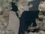
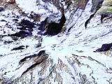
But I digress, this post is supposed to be about the lake! During the 1980 eruption thousands of trees which had covered the mountainside were ripped up and deposited in Spirit Lake. Today, almost 28 years later, they're still there.

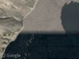
The Douglas Fir logs are slowly sinking to the bottom, but it's a very slow process. Interestingly, the Google Earth image is clearly a composite of two different photographs, one of which must be more recent; across the seam you can see the tree carpet is there in the northern photo, but the majority of logs have sunk in the southern photo2.
More info on Mount St. Helens and Spirit Lake on Wikipedia.
Thanks to Adrian.
-
Mount St Helens was actually one of the first sights featured on Google Sightseeing, way back in April 2005. ↩︎
-
Unfortunately there's no way to date either photograph. ↩︎
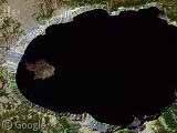
Not only is the image a composite of different photographs but a you zoom out you get yet another view of the log coverage which is different from either of the two pictures forming the composite image,
Did we not have a post about Mt St Helens already? Or is it just one of those places most navigated on Google? Cant believe you’re running out of material…?
Just a thought: maybe the logs have only been redistributed by the wind? As MymsMan pointed out, if you zoom out you will see more logs in the northern part of the lake, but less in the south, compared to what you see in the detailed images. Maybe the logs are floating north?
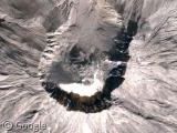
And now let’s check out that original post on Mt. St. Helens!
Well, image resolution for sure has improved since April 2005!
The number of trees in the water is incredible. The area of the southern portion of the lake covered by logs is about 631 acres or just under 1 square mile! Check out this old black and white Live Maps image… http://maps.live.com/default.aspx?v=2&cp=46.271749~-122.141533&style=r&lvl=13&tilt=-90&dir=0&alt=-1000&encType=1
Also in Live Maps when you zoom out you get another view of log coverage. It appears the zoomed out Live Maps and zoomed out GE imagery appear to be either from the same source or same time period. I venture to say the zoomed out imagery and northern zoomed in GE image are older, and the southern GE zoomed in image is newer.
Interesting article here, talks about Army Corp solutions for the lake outlet etc etc http://vulcan.wr.usgs.gov/Volcanoes/MSH/NatMonument/PointsInterest/spirit_lake.html
Many more links/ info here from the USGS, http://vulcan.wr.usgs.gov/Volcanoes/MSH/Hydrology/Lakes/SpiritLake/framework.html Awesome pics here from USGS, look under Spirit Lake section, check out the one with the Water Quality boat http://vulcan.wr.usgs.gov/Volcanoes/MSH/Images/lakes.html
Never say “no way to know” if you’re using Google. The DigitalGlobe Coverage layer on Google Earth reveals that the southern part of the photo was taken on 2nd or 5th October 2004, and perplexingly, so seems to be the case with the upper part. The greener photos that cover the Bear Cove are from August 2006.
Are the logs actually floating? It sounds incredible, considering how many years they’ve been in the lake.
@Ben: Yeah, that post was about the volcano – this one’s about the entirely separate lake 😉
@drR: Good point!
@nova: Cheers for the links – that photo of the miniscule boat is brilliant!
@Dunkleosteus: Good spot – I didn’t notice they were Digitalglobe images.
In fact, I’ve found the exact images in digitaglobe’s archive, and the two images are only 3 days apart! The lower image was October 2nd 2004, when all the logs are clumped together in the south.
The upper image is 3 days later, October 5th 2004 when all the logs have been blown to the north.
Does anyone know why these trees were never removed and taken to a saw mill to be cut up and used?
I could definitely understand the mass of logs moving within days. Winds there can be very high. The logs could also move according to the flow of water with the use of the army corp pumps or the drainage tunnel.
It’s hard to imagine the environmental effect on the ecosystem of the river that was blocked by the mudslide and trees.
I wonder why there hasn’t been an effort to remove the logs, I realize water logged logs probably aren’t much of a desire for flooring or furniture, but there must be some use for them. Any thoughts?
Yes, the logs are floating and they do drift around in the wind quite a bit. The main reason nothing is done with them is that the entire area around St. Helens has been left untouched as a long term experiment to see how the area recovers after the devastating blast/ landslide. I visit the area every few years and it is quite fascinating to see the recovery process.
Here’s what it looks like from the ground: http://www.flickr.com/photos/walkaboutwolf/191407331/ http://www.flickr.com/photos/walkaboutwolf/191407274/
http://www.grisda.org/origins/10009.htm has info on floating logs!