Leaked Images Reveal Google’s X-Ray Spy Plan!
Tuesday, 1st April 2008 by James Turnbull
A Google engineer, who asked to remain anonymous, has just emailed to let us know about an amazing new secret feature in both Google Earth and Google Maps: two new satellite modes which let you see heat maps and believe it or not, literally inside buildings... yes, Google have added both X-ray and infrared thermal imagery!
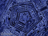
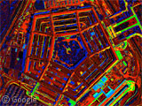
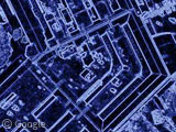
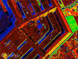
Even more incredibly, the first location to receive the new X-ray and infrared thermal imagery is none other than The Pentagon! Click on the thumbnail images, or load up Google Earth to see these undocumented layers.
The Pentagon recently blocked Google from capturing Street View images of US military bases, but Google have now hit back thanks to a loophole in the law. Because space falls outside of international jurisdiction, the US government is powerless to stop Google's satellites looking inside America's highest security building!
Google haven't made a statement yet so this feature is still completely unofficial, meaning we don't know when it might be rolled out for the rest of the world. However, imagine the repercussions for global privacy if the X-ray and infrared images were combined with the Live images in Google Earth that we reported on this time last year...


And a happy April Fools to you, too.
You forgot to mention you are required to wear special X-ray specs to get the full effect. These can be purchase here:
http://blog.modernmechanix.com/2006/08/15/x-ray-specs/
That ‘aprilfools’ in the kmz file subdirectory makes it quite obvious 😀
april fools!
Nicely done… But unfortunately there is not much too see. The Pentagon seems to be quite a boring place 😉
Not an April Fool! It’s all true! http://digg.com/tech_news/Leaked_Images_Reveal_Google_Earth_X_Ray_Imagery
1st April 😀
I hate to break it to you, but that Google employee was having you on!
Haha, that’s another good one 🙂
This will come in useful for further examination of topless sunbathers…
If anyone uses gmail, you might have noticed this already… http://mail.google.com/mail/help/customtime/index.html
Happy April Fools Day!
Wow.. what a nice feature! Could it also be used to see some deep ocean fishes!? 🙂
1 April 2008.. 😀
Why is it I always fall for these things? doh I’m an idiot. Good one though!
I know an edge detect filter when I see one. 😛
Alas, last years was better (I actually fell for that one =[).
april fools joke or not.. just remember “they” have this.. and will be watching us.
If governments know so much about their citizens why not put this to good use? For example, it should be easy to locate home and business owners who have high heat loss by using infrared imaging from space. I know more than a few people who have not insulated their attics because they are either too poor or just plain unaware. What if a partnership between home and business owners, local utility companies and the U.S. Government were worked out to address this issue? I know an elderly woman in a northern U.S. state who has been completely subsidized for heat over a 10 year period. She has no insulation in her attic. She’s just too poor to hire a contractor to install insulation. Why not have the utility company subcontract this out and then spread out payments in future utility bills?
Why not offer tax breaks to utility companies or building owners based on successive infrared scans from space? Many people are SOO totally against government intervention that they would be against this idea no matter how it was packaged. I ask these people to explain what other options there are? Throw this elderly lady out into the street? Have her freeze? Waste tax payer money year after year after year with massive heat loss?
Hopefully Obama will change things and save tax payers money in the long run. If anything he will likely be more fiscally responsible than W.
Do you know how x-rays actually work? Thermal, Ok (it really exists and in use for quite a while). X-rays, april’s fools.