New Imagery in Google Earth 1st April ’08
Wednesday, 2nd April 2008 by James Turnbull
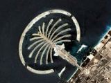
Honest, it's not a prank! Yesterday Google announced new imagery in Google Earth covering all continents and 86 different countries.
Updated: The new imagery is now available in Google maps and the (long) list of what's new has been posted.
Get suggesting those new sights!


I think Llanfairpwllgwyngyllgogerychwyrndrobwllllantysiliogogogoch is a sight in its own right. (Yes, I used copy and paste)
I still don’t follow why some places are getting at least their third or fourth hi-res update when there are still areas with imagery that looks like it was taken by a drunk pilot with his handheld disposable camera hanging out the window. Just my two cents.