The World’s Longest Pier
Tuesday, 20th May 2008 by Alex Turnbull
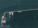
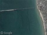
The town of Progreso, Mexico, sits on a limestone shelf that falls away extremely gradually as it gets further out to sea. As a result, when they built a pier to allow cruise ships to dock here, it had to be long. Really long.
Measuring a phenomenal 6.5 kilometers (4 miles), this is the world's longest pier.
The original pier was completed in 1942, and despite being little more than a two-lane highway, is actually quite nice looking seen from the beach. In this satellite shot you can clearly see where the original construction ends, and the more recent one begins.1
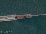
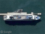
Cruise ships dock here for a day or two to allow the tourists to visit some of the nearby archaeological sites, and we can see there's one berthed here at the moment. Tourists need to take a bus to shore, which takes nearly 10 minutes!
The pier also plays a major part in the local container industry - we can see loads of them stacked on the pier - and there's also a tanker here just now too.
For more long piers, see our previous posts on England's 2.1 km Southend Pier (the world's longest pleasure pier) and Australia's 1.8 km Busselton Jetty2.
Thanks to cboone and Michael.
-
For those of you who care about these things, yes it does look rather like the more recent part of the "pier" isn't suspended over the water, which would technically make this part, er... a wharf? However this makes things far too complex, so we're sticking with pier. ↩︎
-
Confusingly, the Busselton Jetty is the longest wooden pier in the southern hemisphere, but Australians seem to call them jetties. ↩︎
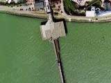
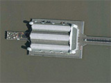
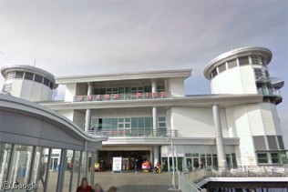
We actually docked here on a cruise last fall — you are not allowed to walk along the pier between the ship and the town, for obvious safety reasons. The shuttle buses are free, though.
Moving north to the United States, there’s the amazing nonexistent pier of New Jersey. It extends a couple of miles into lower New York harbor and allows Navy ships to load ammunition from an onshore depot. It is “nonexistent” because for security reasons, it’s not shown on maps (including Google Maps). A somewhat silly precaution, because it’s plainly visible from shore.
Whoops, my link from the prior message went to the Progreso pier, sorry.
If you zoom out, one of the satellite photos clearly shows the buildup of sand/sediment. And the angle of the waves show the cause – long shore drift. It’ll silt up and make it unusable unless they keep dredging it/extending it.
On that basis, Portsmouth’s Clarence Pier must rank as the world’s shortest – in fact, it isn’t a pier at all, but then neither’s Progreso, which is at most a mole, putatively a caisson breakwater, but never a pier, the essence of whose design is to offer minimum resitence to the water allowed to flow underneath it.
@Jel – As I acknowledged in my footnote, the structure at Progreso may not be clearly definable as any one type of structure. For the first section, it definitely is a pier (letting water pass underneath), but the newer section does indeed resemble a breakwater. Of course breakwaters don’t usually carry vehicles along their length, and where the cargo ship is docked, the structure does appear to become pier-like again.
So I’m sticking with pier 😉
Regarding short piers, the shortest (real pier) in Britain is the teeny-tiny one at Burnham-on-Sea.
I was looking around this part of the country and saw this to the east. It takes the term “spine road” to a new level. https://www.googlesightseeing.com/maps?p=&c=&t=k&hl=en&ll=21.106882,-86.846731&z=16
On Nova’s link, try turning the satellite map labels – obviously the road map data was created at a completely different scale!
I guess that Google is putting more resources into getting satellite images etc. than the road and street maps. The latter being more useful, but the former a lot more attention grabbing and interesting!
@Peter: Is this the one you mean? https://www.googlesightseeing.com/maps?p=&c=&t=h&hl=en&ll=40.450866,-74.044762&z=13
As for the shortest pier in these parts, I’m not sure how the Seaquarium in Weston-Super-Nightmare compares https://www.googlesightseeing.com/maps?p=&c=&t=k&hl=en&ll=51.342589,-2.982109&z=19 But a) it claims to be the last pier to have been built in Britain and b) it’s got some funky effects going on with the roof …
@Peter & Tammo: That’s the Previously featured Earle Naval Weapons Station.
http://en.wikipedia.org/wiki/Naval_Weapons_Station_Earle
Piers dont get much shorter than this! Wigan Pier View Placemark
@cookie monster: Did you just dissapier ?
No – i still ap-pier to be here!
this is the Italian longest pier, near 2 km i think, in Vada
https://www.googlesightseeing.com/maps?p=&c=&t=h&hl=en&ll=43.355484,10.435252&z=15
about the shortest.. in Venice there are some long about 30 centimeters XD
I just measured this pier on Google Earth, I came up with 1.02 miles or 5,402 feet long.
After that, what you call a “pier” is actually a causeway.
It is a little more complicated to build a pier to withstand the elements then it is to dump some earthen material in shallow water and surround it with rock rip-rap.
I have actually been on the pier at Earle NWS in New Jersey and I will attest that it is an actual pier.
This is not to start a flame war, just pointing out what was obvious to me the first time I viewed the imagery in Progreso.
In case there is some debate on this, here are some definitions: Pier: 1. a structure built on posts extending from land out over water, used as a landing place for ships, an entertainment area, a strolling place, etc.; jetty. 2. (in a bridge or the like) a support for the ends of adjacent spans.
Causeway: 1. a raised road or path, as across low or wet ground. 2. a highway or paved way.