Obama Gets Personal Google Earth Update
Tuesday, 20th January 2009 by Alex Turnbull
Update: As expected, GeoEye has released the satellite image they took of the inauguration today. You can directly download a higher resolution [698KB] version too.
Today, the 20th of January 2009, the USA inaugurates its 44th President: Mr Barack Obama.
To mark the event, Google has brought many image updates to the city of Washington DC (which has unsurprisingly never suffered from poor quality or infrequent imagery updates)1.

The update also removes the obscuring "blur" that previously covered the Whitehouse and Naval Observatory, albeit through some clever blending of new aerial and older satellite images. Read more about this on Ogle Earth blog.

Obama's inauguration ceremony will take place to the west of the Capitol Building. Then a parade is held from the Capitol Building to the White House. Google Maps Mania has a summary of several useful maps for viewing the inauguration details and news.com.au have produced a Street View tour of the parade.

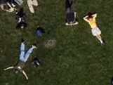
The most exciting news however might be that the Google-sponsored imaging satellite, GeoEye-1, will be covering of the event. The satellite will passing over Washington DC at precisely 11:19am, taking unique pictures of the inauguration from its 423 mile-up viewpoint.
These images are likely to be particularly fascinating as the inauguration is expected to draw a record-breaking crowd of over two million people2. Unfortunately, it's unlikely that these images will be included in Google Earth (as they're lower resolution than the current aerial imagery), but they will be visible on the GeoEye website just a couple of hours after being taken.
For more on the inauguration, Google Latlong have collated some of the best mash-ups, Jason Kottke links to where you can watch it online and finally, if you just want the basic fact of it all, isobamapresidentyet.com answers your burning question.

And the correct answer is: Yes. Finally: YES!
And, ironically, the Missing Dictator Special is listed as related sight!
Yey, pics
http://www.geoeye.com/CorpSite/gallery/Default.aspx?gid=1
Boston Globe has an awesome satellite photo at the time of the inauguration:
http://www.boston.com/bigpicture/2009/01/the_inauguration_of_president.html
I highly recommend this fantastic pic of the inauguration, taken during his speech. http://gigapan.org/viewGigapan.php?id=15374
It’s highly detailed and you can zoom in for great details.