The Mysterious Case of the Vanishing Airport
Monday, 9th March 2009 by Alex Turnbull
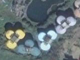
This is Naval Air Station Sigonella, a U.S. Navy installation in Sicily, Italy, as seen in this image on Google Earth that was originally captured on June 27th, 2006.

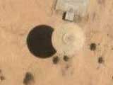
This next image of exactly the same area is from Microsoft Live Maps, and far from simply being a much older image taken before the facility was built, this was actually captured in 2007...

Thanks to widespread coverage, many people are now familiar with the idea that "sensitive" areas of our planet are being hidden from view in the images that online mapping services display.
It's also commonly understood that the images are usually altered by the company who originally took them (rather than Google, Microsoft, Yahoo, or any other buyer), allowing them to remain in line with their local laws and regulations.
Such areas include military installations, government buildings, and airports - but the point is usually simply to prevent people from viewing the exact details of the site, rather than attempting to deny their very existence.
Last year we saw some imagery in the Netherlands had been altered in a more dramatic way - drawing the ridicule of the Photoshop Disasters blog in the process - which in turn led to even wider recognition of the attempted cover up.
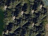
Well, it seems that the companies engaged in these activities have been paying attention, because closer examination of the supposed location of NAS Sigonella reveals that while there are clearly artificial repetitions of parts of the image, the overall result is by far the best Photoshop job we've seen on either MS Live or Google Maps.

Unfortunately, to the west of the site we can still see part of a runway that our inexperienced Photoshopper neglected to cover up - so there's definitely still room for improvement.1

So is this the start of a new trend? Will satellite and aerial photography companies now need to employ full time digital artists to hide things the governments don't want you to see? Or is this just another example of Microsoft attempting to up the ante against Google?
Read more about NAS Sigonella at Wikipedia.
Thanks to Al Cohole.
-
TerraItaly are the company responsible, and this isn't their first failed cover-up job. ↩︎
I’m not sure the sticking out “runway” is an active part of the installation. The GM view shows that the runway is already terminated and there’s a road between it and the sticking out part. Perhaps it is from an era before the airport was military, or a planning mistake, or land was ceded at some point. So the bounding box of the military plot doesn’t include the vestigial snip of runway.
What’s funny about both of these Italian military airport spots is that if you zoom out, the existence of an airport is obvious.
Future military secrecy will involve hiding in plain sight instead of the old black ink tricks. Heck, both sides in WWII some 65 years ago had impressive aerial camouflage.
I think the visible “runway” part was never a part of a runway. On closer inspection, it looks more like an approach lighting and/or ILS array, as common at many airports: http://en.wikipedia.org/wiki/Instrument_landing_system
Ok, the patch of the runway you see is still active. The US and the Italians share the runway and many other parts of the base. I think some just wanted to start a conversation about this, which is OK. But like you said, hiding in plain veiw is the real trick. The first photo holds more secrets than all the others. Happy hunting.
If you reduce zoom you can see the airport in low resolution. And if you do so you also will notice that another area is manipulated. Look on the west side of the road SS417 when it goes almost south. On Google you see some training area with bunkers or something like that. MS Live only shows green…
BTW: Yahoo picture seems to be even better:
http://maps.yahoo.com/#mvt=h&lat=37.407496&lon=14.916214&zoom=17&q1=37.401667%252C14.922222
Yet Google has high-res pictures of the most secret U.S. military base of all, Area 51.
and Guantanamo Bay!
’cause Area 51 is a testing ground, it doesn’t matter whether the installation can be seen or not but the subjects it tests have to be hidden. Considering it’s in the middle of nowhere and well protected it’s not really a target
However, an active base, if detailed from above like so, can easily become a target due to identifiable weaknesses and like strength within the base.
It’s fine knowing these places are here but hiding the details are what’s important.
So have you ever seen runway markings like those at the bottom edge of Area 51? Conventional taxi paths leading to semi-circular pads…
I found an example of editing in GE a few years ago but it got replaced with newer data soon after. Luckily, with the add of historical imagery, you can see it again!
Go to the Port of Los Angeles (Long Beach), enable historical imagery, and move the data slider to Dec 31, 2003. Zoom in on the ships in port, and you will notice repeating container patterns. Look around at the cranes, and you will see they are replicated copies.
Alex, you are reading way too much into this. As you have shown Google Earth still has the Sigonella runway. It seems to be more like incompetence on the part of Microsoft Live Maps and Billy Bob Gates. Assuming that Google Earth is correct, which it seems to be. Notice on the Microsoft map there is a road that leads south then makes a sharp turn into the end of the runway. On Google Earth the same road makes a sweeping curve to avoid the end of the runway. Also if you look to the north on Google Earth you will see a large apartment complex. This does not exist on Microsoft; it seems the only thing that Microsoft got right was the roads and the river.
Warning: Don’t use Microcrap as a reliable source for anything.
One could have some fun with this, by capturing images and altering them yourself with even more bizarre stuff, then publishing them with the lat/lon and letting the government and conspiracy theorists go crazy.
Not that I would ever do anything to embarrass or inconvenience the government, but I do know a guy who has… 😉