World’s Largest Movable Technical Industrial Machines
Tuesday, 31st March 2009 by Ian Brown
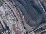
The mining regions of Germany are home to five of the world's largest movable technical industrial machines - the Overburden Conveyor Bridge F60.

Larger than the Eiffel Tower, these machines weigh 13,600 tons and are up to 502m long, 80m high and 240m wide. 760 wheels carry them along rails at a rather sedate top speed of 13 m/minute. Two excavators can move up to 29,000 cubic metres of earth an hour, exposing coal seams for mining.
There are 3 operational F60s - in Jänschwalde (first image, above), Welzow-Süd and Nochten.


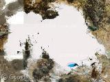
In addition there is one being updated with newer technology in Reichwalde, though it's partially obscured by a massive paper airplane that was apparently flying over when the Google satellite was taking pictures!

Finally, the last F60 built is located in Lichterfeld-Schacksdorf. It was only operational for 13 months, but is now open to tourists. The European Route of Industrial Heritage has more information and a good gallery.

Thanks to Martin Zwirner.
About the author
Ian Brown lives in Ottawa, Canada, and spends his spare time perusing maps to find new routes to ride on his orange bicycle.
The scary part is comparing it to the villages nearby, which are about the same size…
That giant paper plane also appears on Live Maps… http://maps.live.com/default.aspx?v=2&FORM=LMLTCP&cp=51.404788~14.702722&style=h&lvl=16&tilt=-90&dir=0&alt=-1000&phx=0&phy=0&phscl=1&where1=51.404212%2C14.700694&encType=1
I wonder why that imagery is unavailable?
Interesting – and if you compare them side-by-side it’s obvious that Google does more image processing to improve the images than Live Maps does.
Alex- do you know how much the two services use the same imagery? I hadn’t noticed many cases like this where it’s obviously the same image source on both sites.
Strangely it used to be the other way round – Microsoft used to process the images much more heavily (which was why Live maps imagery looked much better).
I don’t have any evidence about how much imagery is shared, but anecdotally they seem to be sharing more and more imagery these days.
Perhaps both services are just buying the best available imagery in most cases?
Just above the paper airplane you see some colour differences:
https://www.googlesightseeing.com/maps?p=&c=&t=k&hl=en&ll=51.407077,14.708719&z=16
Looks like they have been stitching images together in a strange way, and were left with a gap… Perhaps this was once a giant jigsaw puzzle?
Near there, at one of the power stations, someone made a major mistake on one of the cooling towers. It’s leaning the wrong way compared to the rest. 😉
View Placemark