Chinese military weirdness
Tuesday, 18th August 2009 by RobK
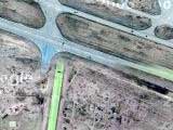
There aren't many sights that puzzle us here at Google Sightseeing, but this one has us stumped. In a remote desert area of Gansu province in northern China is this mysterious maze-like pattern.

The "streets" are about 20 metres wide, and the pattern occupies a rectangle measuring about 1km x 1.8km, aligned north to south and so sharply defined that it almost appears superimposed on the image. If you zoom in, though, you can see that the lines really are there on the ground.

Exploring the surrounding area, things get weirder. A short distance to the west are what appear to be a series of runways in various states of repair. But where are the support buildings and access roads?


At the northern end of one runway, there seem to be bomb craters. Could these be fake runways built as aerial bombardment targets? These mysterious blue-roofed buildings also seem to have been blown up.


Further west again, what's this? Another big maze rectangle, this one looking old and faded. And just beyond... a circular arrangement of vehicles, planes and... other stuff, laid out over a 12-pointed star pattern. Another target? The plot thickens!


Frankly, we could fill a week's worth of postings with the odd stuff on display around here. What are all these suspiciously regular shapes filling dry river beds, with signs of excavation and vehicle tracks? Could they be giant sandbags being filled and then carted off for construction work? If so there are thousands of them!


If any readers have any theories (or if anyone in the Chinese military happens to be reading!) then we'd love to know. One thing we do know, thanks to Google Earth's historic imagery feature, is when the "maze" in our first photo was built. A photo dated April 14 2005 shows it partially completed, but by May 30 it was all finished.

Thanks to Garret.
About the author
Rob is a subeditor and freelance writer from Hampshire, England, who enjoys travel both real and virtual.

WTF! This is strange!
BTW what are those blurry things? Sand which has been washed overt pavement?
Thats creepy man and the nature is weird everywhere what the hell is this place!!
More weirdness to the west of the first maze: View Placemark ..and to the east of that, does these look like the shadows of of an electrical substation or some really fun swings?! View Placemark
Looking back in time at the 16 ‘building’ You can see that in 2003 they wern’t even there and progression of their distruction. I don’t think the squares are buildings though. There are no shadows. You look at the vechiles however and their are. shadows, along with evenly placed box like structures.
I think that the squares are impact locations for aiming missiles at. You look at them and they are broken into numerous strips. DIffernet materials perhaps. The vechiles are then placed in various locations, along with the regularly placed boxes, and you can test the effects of a missle impact on differnent materials (asphalt, concrete, etc). One of the things that I find odd are that in May of 2005 you can see what looks like walls running along within the area, but in Sept they’re gone. Not a trace left at all, thats also when you start to see the squares start being destroyed.
Nic – I’d spotted those too but was running out of space!
Your first link is, I think, more bombed out buildings. If you look on Google Earth and go “back in time” using the historic imagery slider, you can see that the structures used to have roofs, and vehicles parked neatly between them, and they then were destroyed in stages.
I’m pretty sure the second link is indeed an electricity transformer station of some kind.
My guess on the mysterious maze would be a series of camouflage runways. Maybe an attempt to confuse people. There are a few sections that look like they can be used for aircraft.
Or, They got a road building machine and they took it out for a spin, while knocking back a few beers.
Now THIS is the kind of post I come to GSS to see, not some stupid windmills or monuments. I want to see the WIERD stuff!
Here is a copy of an email i received in reply
Dear Mr Monster Thank you for enquiry regarding our military weirdness. Mind your own business. Lots of love The Chinese Military
Could the rectangular patterns be some kind of calibration image for (spy) satellites?
It’s a digital watermark.
Google places these random patterns so they can automatically spot those who are half-inching their datas.
That’s what I thought it might be at first, Martin, but if you zoom in you can definitely see it is really there on the ground. And as I pointed out, you can see it half-built on Google Earth, complete with the trucks being used by the construction workers!
Hmmm…. Followed the road running north past the weird maze. It took a turn to the west, and past some weird stuff here:
https://www.googlesightseeing.com/maps?p=&c=&t=k&hl=en&ll=40.513245,93.242877&z=16
Perhaps it’s China’s alternative energy program? Looks like windmills (sorry Mike) and perhaps solar panels. I’ve read somewhere a while ago that China is doing some of that stuff in Western Gansu.
Those two towers appear to be radio towers to me.
Here’s a photo of the building from Panoramio. One of the towers can be seen in the background.
http://www.panoramio.com/photo/3728890
I see a satellite dish and two cellular antennas.
And two taxis. Must be high security!
This is pretty crazy. Here is my best attempt to explain away the crazy…
If you look slightly North East of the runways you will see what appears to be an old strip mine. If you look at most of the nearby roads you will see perpendicular scrapes to the roadway. They probably used the waste dirt from the strip mine and road construction to help control erosion in the valleys. This would explain the piles if dirt.
The runways, buildings, etc. were probably used as training area for bombing or other similar activities. The mazes were probably used to help trail pilots how to navigate roads from aircraft.
If you follow the road the other way, there’s a checkpoint:
https://www.googlesightseeing.com/maps?p=&c=&t=k&hl=en&ll=40.337631,93.755833&z=17
Great entry! I think these structures were only built for weapon testing, to represent typical first-strike targets: Runways, underground bunkers (the suspiciously regular shapes?), electrical substations, vehicles and buildings. The pattern they are built in is (a) dense for maximum airstrike impact probability, and (b) weird/nonsensical (no support buildings or access roads) because the structures are not designed to ever be useful (other than for being destroyed again, of course).
Does anyone know what the coordinates are? I’d like to look this up in Wikimapia and see what people are saying.
Try 40.4509N, 93.7435E.
Wikimapia says “Test targets”. I hadn’t thought of looking there…
Already discussed here http://bbs.keyhole.com/ubb/ubbthreads.php?ubb=showflat&Number=469501&site_id=1#import and here http://bbs.keyhole.com/ubb/ubbthreads.php?ubb=showflat&Number=504658&page=1
Conclusions: Structures in the west – visitors centr of Sanlongsha Yardan Formations. in GE you can even see the gate and windmills in 3D 🙂 Generally very touristy albeit remote area. Other attractions – remains of Han great wall – you can see the wall actually quite nicely south of this area. the rest is military area. Patterns and structures are targets for cruise missiles and drones – mission – find and hit intended crossroad.
So I’m more than three years out of date! Great links there asdf. It still leaves mysteries though – like why on earth they chose that particular pattern of zigzag lines, painted so previsely onto the desert within a rectangle? If you look at the top right-hand corner there’s even a tiny section of line on its own, not attached to the rest of the “maze”.
If you look at the second image from the bottom of this page: http://bbs.keyhole.com/ubb/ubbthreads.php?ubb=showflat&Number=504658&page=1 you can see older imagery of the bombed out “camp” mentioned in Nic’s comment above, before it was bombed out… as it is now: https://www.googlesightseeing.com/maps?p=&c=&t=h&hl=en&ll=40.413774,93.583925&z=17
There were also some pretty cool links to Chinese slogans carved into the desert, e.g. View Placemark
Don’t know about the mazz lines, but there’re some presse coverages about the run way sometimes ago:
They are fake and representing some military airports in taiwan.
Not to forget the scale replica of a whole mountain range (identified as part of a territory contested between China and India): View Placemark
Did we have this here already?
China’s scale model: https://www.googlesightseeing.com/2006/08/06/1019/
Interesting positioning, though: China seems to want to fight on their own side of the border. Given it’s a convenient kicking-off point if they’ve been thinking of taking out New Delhi inside of a week, and abutting Jammu and Kashmir, one begins to see the strategy: provoke India into a killing zone and strike on the rebound, much like William the Conqueror did at Hastings but on a much larger scale. At least this time India is forewarned…
The “sandbags” are not really sandbags but I believe boulders washed down from the mountains. They appears to be fairly regular at about 10 feet in diameter (only an estimate). They are probably “harvested” as some kind of construction material for foundations or walls. You can see individual boulders if you follow the river bed further down stream. It may also be possible that some of these would be used as practice bombs for training purposes prior to letting bombers use live ordnance.
After a second closer look the sandbags look more like two distinct types of man made objects and not boulders. There are a group of larger one that seem to look like bales. They appear to be strung in three sections and each to be about 20 feet in length. They have been washed down river over the runway. The other smaller ones look like barrels about 10 feet long. They are to the right of the runway grouped together by another section of the flash flood. It’s possible these are some sort of supplies flown in for the work being done there or raw materials from the area that were being flown out that got caught in an unexpected flood.
After looking again, at the sandbags, I think they may be just marks left in the sand by vehicles that have been scooping up sand on the riverbed.
Im pretty sure the maze like pattern is a digital watermark, but a slightly less blatant one. it looks like its just been photoshopped with the original image overlayed over the top… anyone else think this is likely?
I don’t think so – in the historical imagery you can see pictures of the ‘maze’ partially completed.
Maze is most certainly not photo-shopped. If you zoom in on one of the photo to the left of the one with the jets, you’ll see that there is weathering of them. Wash outs over them . Sand and deposits washed over them. They were even painted over fissures in the earth’s surface so they certainly were not meant to be roads or airstrips.
My best guess for the circle of vehicles is that its a target designed to test missile strikes. In fact I would hazard that thats probably the purpose of all of this location. The “maze” is most likely too test the accuracy of precision bombing, as in, whoevers in charge says which “intersection” or “block” that they are supposed to attack and then they do it. The maze like structure would be intentional to confuse a pilot. The idea being to train them to attack specific targets inside a city or military base with a low margin of error.
I’m becoming a GSS addict ! I I’d say this is either for weapons testing or their building a new Disney Theme park and its the parking lot.
Ever Take a look at the Baryy M Goldwater Range in Arizona? Exact same types of stuff: View Placemark (32.454,-113.184)
Just looked at your suggestion and it has none of the weirdness that this Chinese site has. You must be seeing things.
military storage bunkers maybe ammo or bombs you can see similar us type storage place just east of Gallup New Mexico and south of interstate 40 they use mud huts we use quancet huts. One with planes it to test bomb blast spread measuring out from the blast center search Barry Goldwater bombing range Arizona for US version ,Theirs are cheaper bigger and newer make a person go hummmmm ??
quancet is spelled Quonset for Quonset Point, Rhode Island where the Davisville “Sea Bee” Base was located and the Quonset Hut was developed.
The place was used as a military test zone for experimental missiles created by the Xinshidai.