Bouvet Island (Island Week 4)
Tuesday, 29th September 2009 by RobK
It’s Island Week 4 here at GSS, which means we’ll mostly be posting about Islands. For about a week.
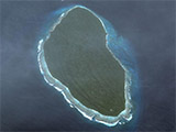
Far out in the South Atlantic, more than 2,500km from the coast of South Africa, Bouvet Island is the loneliest chunk of land on Earth. With the exception of a few tiny rocks just offshore, its nearest neighbour is Antarctica, 1,750km to the south. Despite being so remote, and totally uninhabited1, it is covered by some beautiful high-resolution imagery.


Bouvet Island is a dependency of Norway, although it was discovered by (and named after) a Frenchman, Jean Baptiste Charles Bouvet de Lozier, in 1739. It's a volcanic island, almost entirely covered by snow and ice — you can make out the central crater surrounded by cloud-covered peaks, with the highest, Olavtoppen, casting a shadow from the northeast.

Landing here is a very tricky prospect, unless your ship's equipment includes a helicopter: the coastline mainly consists of high cliffs, with stormy seas foaming at the base and carving out sheer stacks of rock. In places, glaciers tumble over the edge in jagged blocks of ice, while submerged rocks lie in wait for unwary sailors. It's no surprise that the island remains uninhabited, although a group of hardy Norwegians did spend a whole month there in the 1920s, confirming the nation's claim on the island.


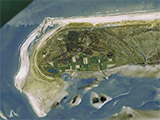
It seems Bouvet is still volcanically active. During the 1950s, an eruption on the west coast created a low shelf of lava — just about the only convenient flat spot on the island. The Norwegian Polar Institute installed a research station there in 1994 for use during field trips to the island, but by 2007 (and on Google's pictures) no trace of it remained. The official story is that an earthquake caused a landslide that swept the portable building away — or broke the guy lines that anchored it, allowing gales to blow it into the sea — but bearing in mind that Bouvet Island was the setting for the 2004 film Alien vs Predator, the real explanation seems obvious... 🙂


One final mystery: can anyone tell us why, according to the map at Wikipedia, this headland is called Cape Circumcision?

About the author
Rob is a subeditor and freelance writer from Hampshire, England, who enjoys travel both real and virtual.

To answer my own question about “Cape Circumcision”, it seems the answer is rather mundane: the cape was first sighted on January 1, which in the Catholic calendar is the “Feast of the Circumcision of Our Lord”.
And there was I picturing daring shipboard operations performed only with a sharpened whalebone… 🙂