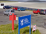
Luzamba airport: plane-wreck central
Wednesday, 7th October 2009 by RobK
If you're a nervous flier, you'd do well to avoid Luzamba airport in northern Angola1. It's not so much that lots of aircraft crash here (although it seems it's hardly a rare occurence) — more the fact that the wrecked planes are simply left scattered around the place.

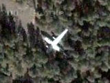
There are at least four: first up, at the northern end of the runway, an Air Angola Antonov An-26 which overshot the runway in February 1999, killing 2 of the 36 people on board. The International Civil Aviation Organization's report suggests that the crew might have been drunk. There's a ground-level photo of the wreckage on Panoramio2.


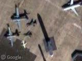
At the other end of the airport, and seemingly in better shape, is a Transafrik L-100-30 Hercules (a civilan version of the C-130), which also overshot the runway later the same year. Happily, there were no casualties in this incident. Again, Panoramio features a ground-level photo, which reveals that the plane has been stripped of its engines and other salvageable parts.


In the trees to the east of the runway are another two crashed planes: one that looks almost as big as the Hercules, and another much smaller one about 50 metres away. Extensive research by Google Sightseeing (or a bit of Googling, at any rate) has failed to identify these planes, although there is a photo of one of them on Panoramio, too, and it looks as though it's been lying there for some time. Can anyone identify it?


Lastly, it's hard to tell from the aerial view, but could this be another piece of wreckage just on the other side of the runway from the last two planes?

Thanks to John.
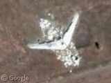
the plane in the last photo looks like it may be a dc6
TAAG Airlines were banned from the EU and they retaliated, banning British Airlines and they were thinking about banning Air France and TAP too.
A dumb move, instead of adopting security measures on their planes they preferred to retaliate.
Now they can fly to Portugal, but only with two airplanes that are approved.
Yup, that’s a DC-6 in the last pic.
the unidentified wreck looks from the front to have a DC3 cockpit, but it has 4 engines. could be a DC4 or DC6.
Ok for the DC6 : Two other parts of this aircraft : near the fuselage lie the horizontal part from the tail, withdraw the mobile parts, and other side of the runway is the vertical part of empennage (also without mobile part). See plan at http://richard.ferriere.free.fr/3vues/dc6_3v.jpg and drawing at http://img33.imageshack.us/img33/9232/dc6wreck.jpg
MiGo
Interesting stuff – so it’s not a second small plane but the tail of the big one!
Can u all help me? I looking in google earth for a planecrash in +/-1969. The is a problem, the plane crash was on the sand dunes in south of Angola (Baia dos Tigres seacoast). I already found a helicopter crash in google earth, and than I visited the spot (never discover before). Waiting for your help. A. Baptista
I’ll give it a shot. Big country, though. Got any more detail? I googled it and got nothing, but maybe if you give me a little more info about the location, I could find it for you. By the way, any particular reason you want to find this wreck?
Sure it wasn’t Namibia? there’s a wide expanse of desert to the west there.
Sorry mate, I got nothing. At least on Baia dos Tigres seacoast. Besides a couple abnormal shapes that are most likely nothing, here: 1633’01.30″S 1140’18.33″E and here: 1631’03.91″S 1142’48.19″E. Explore the east coast of the island and you might find something interesting, too, but I doubt that any of it is your plane.