Interesting Exclaves of the United States
Tuesday, 20th October 2009 by Randy Nickum
New writer: Randy Nickum Randy is a lifelong resident of Cincinnati, Ohio, in the Midwest U.S. He has travelled widely across his country as a consultant and has visited six of seven continents, missing only Australia so far.
An exclave is defined as "a territory whose geographical boundaries lie entirely within the boundaries of another territory." Practically speaking, it is a portion of one territory that cannot be reached by land without first passing through another.
There are several examples of exclaves in the United States. One of the best known (and previously documented on GSS) is Point Roberts, Washington, an area of the state that can only be reached by first travelling through British Columbia, Canada.

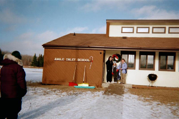
The exclave of Point Roberts was created by the 1846 Oregon Treaty, which set the boundary between the United States and British North America at the 49th parallel north -- with one exception. Due to various mapping mistakes and confusion over the location of the headwaters of the Mississippi River, the U.S.-Canada border juts northward to include a chunk of land lying north of the 49th parallel. This area, now part of the state of Minnesota, is known as the Northwest Angle.

The Angle (as it's known by locals) can only be reached via a single gravel road through Manitoba, and visitors clear Customs in both directions via videophone in a small unmanned hut. The total population of the remote, 300 square km (116 square mile) township is 152, and it boasts the only remaining one-room school house in the state.
Just below the 49th parallel, and also cut off from the mainland of the U.S., is Elm Point, Minnesota. Elm Point is remote, uninhabited and roadless, yet satellite imagery appears to show a line cut through the forest at the U.S.-Canada border, presumably for clear sight lines along the border. Who would see any illegal activity along those sight lines is an unanswered question.

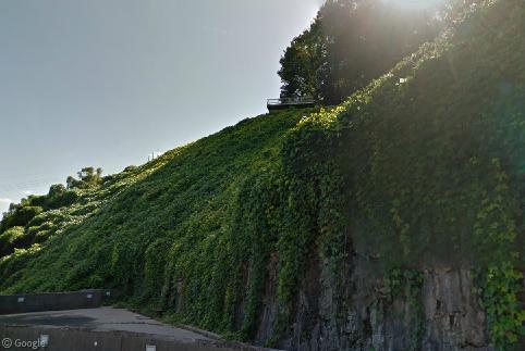
Alburgh, Vermont is a pene-exclave of the United States. Now before our dear readers crash the GSS servers thinking a pene-exclave is some sort of French rudeness, a bit of definition: a pene-exclave is an exclave for practical purposes, without meeting the strict definition of an exclave. In the case of Alburgh, the town lies on a peninsula connected to Canada (like Point Roberts and the Northwest Angle) but is linked to the rest of Vermont and neighbouring New York via bridges. These bridges serve as the only road route across Lake Champlain.

Among state borders within the U.S., many exclaves have been created over time by the meandering of flooded rivers. In these cases, legal boundaries remain in force, even though river courses render some areas cut off from the rest of their respective states. Among the most prominent examples are the Kentucky Bend and Carter Lake, Iowa.
The Kentucky Bend is an area of Kentucky that is completely surrounded by the states of Missouri and Tennessee. The Mississippi River passes over a geological fault in this area, and The Bend was formed by a shift in the course of the Mississippi River after an earthquake in 1812. A later surveying mistake (again with surveying mistakes?) while setting the Kentucky-Tennessee border created the division. The 44 square km (17 square mile) area is home to just 17 people. No bridges connect The Bend with the rest of Kentucky, and if you wish to send mail to someone in The Bend, his official postal address is (confusingly) in Tiptonville, Tennessee.

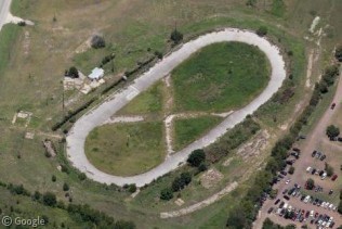
Finally, Carter Lake, Iowa is the only city in Iowa that lies west of the Missouri River. It is completely surrounded by Omaha, Nebraska, and was formed by a flood that straightened the course of the river in 1877. After a set of legal disputes Carter Lake was determined to be part of Iowa, and later became a recreational hot spot, offering casino gambling even though the rest of surrounding Nebraska outlaws it. The town's utility services come from Nebraska, while children attend school across the Missouri River in Iowa. Travellers in Omaha driving to the city's airport pass through Carter Lake1, where signs reading "Welcome to Iowa" confuse many panicked out-of-state visitors.

You can read more about the Northwest Angle, Elm Point, Alburgh, the Kentucky Bend, and Carter Lake (along with a huge worldwide list of exclaves and enclaves) at Wikipedia.
-
On Iowa's shortest state highway, which is only 823 m (2,700 feet). ↩︎
Interesting post – I love this kind of stuff. A similar situation to Carter Lake is Rosecrans airport, which seves St Joseph, Missouri, but has been cut off from the rest of the state as the river changed its course during the Great Flood of 1951:
View Placemark
Not forgetting one of the most famous excalves in the United States – Washington D.C. The district of Columbia is only accessible through another US state, namely Virginia and Maryland.
View Placemark
Great first post Randy.
Looks like just a tiny bit east of the Vermont pene-exclave is a proper exclave, uninhabited which might be a contender for the smallest exclave.
https://www.googlesightseeing.com/maps?p=&c=&t=h&hl=en&ll=45.013224,-73.193235&z=14
A “political” Swiss exclave in France: EuroAirport (View Placemark). This airport serves three cities: Mulhouse (France), Basel (Switzerland) and Freiburg (Germany). Although the airport is entirely on French territory, the terminal is politically divided between a French half and a Swiss half, with separate access roads, separate parking lots, separate car rental facilities, etc. The Swiss half is on the South side and can be accessed from Switzerland through a “Route Douanière,” a road that goes straight to the airport through French territory but with no connection with the French road system and no customs to go through.
Following on from Didier’s post, there is also a “proper” Italian exclave in Switzerland – the town of Campione d’Italia on Lake Lugano:
View Placemark
Google Maps doesn’t show the border of the exclave, but you can see it in Bing Maps:
http://www.bing.com/maps/default.aspx?v=2&FORM=LMLTCP&cp=45.971674~8.971796&style=r&lvl=13&tilt=-90&dir=0&alt=-1000&phx=0&phy=0&phscl=1&encType=1
While working on a European scale, there’s a sizeable chunk of Netherlands on the Belgian side of the Schelde. This arose because the various administrative areas caught up in the 1830 Belgian revolution were given a say as to which country they wished to be part of – the result is a number of minor enclaves all along the Belgian border, particularly in the north-east, where there are even instances of the border running through the middle of some houses.
This is nice mess exclaves in other exclaves:
https://www.googlesightseeing.com/maps?p=9163&c=206889&ie=UTF8&ll=51.329754,3.882294&spn=0.55346,1.454315&t=h&z=10
Its not correct to say that the Northwest Angle is the only exception to the setting of the border west of Lake of the Woods along the 49th Parallel.
The major exception is the southern section of Vancouver Island. If the border followed the 49th parallel, Victoria and surrounding areas would be a United States enclave similar to Point Roberts.
Randy, et al, would this be an exclave? 45.002N, 73.798W