The Nonexistent Town of Argleton
Tuesday, 3rd November 2009 by Alex Turnbull
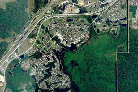
Nestled in the Lancashire countryside, just to the south of Ormskirk, is the small town of Argleton. Or so Google would have us believe.
Zooming in closer reveals that Argleton isn't exactly a bustling metropolis. In fact it looks suspiciously like a couple of fields.
Roy Bayfield of Ormskirk was so intrigued by the mystery that he walked to the centre of Argleton just to check that there was definitely nothing there. There really wasn't.
So where has Argleton come from? Some of Aughton's 8,300 residents believe that it's the result of a simple mispronunciation, but conspiracists have suggested another theory.
The map data used here comes from Tele Atlas, and it has long been known that cartographers sometimes alter their maps as a way of protecting their intellectual copyrights. Usually this takes the form of Trap Streets (which are designed to "trap" people who steal the data, as they copy the unique mistakes along with everything else), however in this case, is it possible that Tele Atlas has invented an entire town?
In the past the inclusion of a fake town in a map would have likely caused no harm, but in the age of automatic content generation, Argleton was building up a fair bit of fake history.1 Simply by having been declared to exist, automatic listings were being generated for it, meaning that is someone were to look it up online, they would believe it to be a lively town with jobs, hotels and schools.
Of course one final possibility remains - that Argleton is simply a mistake. Consider the fact that just a few kilometres to the north, Google has quite brilliantly renamed a local cul-de-sac to Dummy 1325.
Thanks to Google Maps Mania for alerting us to this one, which was originally posted by Mike Nolan at the Edge Hill University.
-
Before the story of Google's sinister activities swamped the rankings that is. ↩︎


How do you know the street isn’t called Dummy 1325? Has anyone been there to check?
Would be great if you contribute to my Google Maps trap street/name map, which is open to edit for everyone
I believe this is a case of “watermarking” the map data to see if it is being stolen by 3rd parties.
I find it interesting that “Dummy 1325” becomes Smithy Lane, as in Alan Smithee???
It looks like Google isn’t the only site that believes in Argleton.
Multimap
It’s possibly a mis-scan of the neighbouring Aughton – the usual OCR spell-check finagling. What I DO find amusing is he number of scam merchants who appear if you search Argleton -goolge. The usual suspects, holiday and estate agent lets, T-shirts, a Rapper, employment agencies, medical – about the only thing not spotted is a niagara factory (well, you know what I mean).
Evriona in Australia is sort of similar
View Placemark (-35.400000,149.180000)
Simon, the map actually says “Environa”, not Evriona.
Isnt it possible that it’s similar to the case of Ravenscar, also mentioned here? That there were plans to build something there but it’s somehow never been realized, but the map somehow reflects the plans? Because it sure doesn’t look like something put there by mistake…
bio
It’s getting nteresting: I wikied up Environa and it’s mentioned as a suburb of Queanbeyan City. It is listed in the “It includes the suburbs and villages of:” list, so it’s definitely not a planned something, but mentioned as an existing suburb/village. But the fact that Wiki mentions it makes it clear that it’s NOT a Gmaps error of some kind – unless Wiki took the info from Gmaps, of course 🙂
bio
… while Argleton appears in Wiki also, but as “a non-existent location in Lancashire , UK, notorious for appearing on Google Maps but not in real life.”
Wiki 1 GMaps 0 😀
Sorry for the flood.
bio
It would be quite interesting for Google earth to do an item of Ravenscar, the town that never was, where an extensive road network was laid out for a planned resort that was never actually built, because for a seaside resort it lacked the basic requirement of an accessible beach! http://www.enjoyengland.com/destinations/find/yorkshire/north-yorkshire/ravenscar.aspx
It is also one end of the Lyke Wake Walk path.
I’ve been there, It is very quite and peaceful. It’s a place you can go and be assured no one will mess with you. I plan to go there again. When I get some time off work
It transpires that “Argleton” is an anagram of “Not Real G”.
Curiouser and curiouser…
And what about “Not Large”? 😀
bio
This is nothing nw .. the Ordnance Survey have been doing this sine 1920 as a means to protect their copy right. The main point ist that the OS have now been legally obliged to provide their data and maps free of charge. So why are Google’s providers still at it?
This is just a test in order to check i-net navigators & geographers, nothing else. If t akes some time (say a couple months) for them to find the boo-boo it means that they are either inactive or lack attention. This goes on line with disinformation techniques, per MI-5 & CIA manuals. The Germans or the Russians may come but they’ll find nothing. Watch the others…
Following on from my previous post I went to look at the OS website – indeed they have been selling their product to Google in GML (Geographic Markup) format, and it still contains these checks against copy right. This is mainly aginst individuals using the data for their own profit, and so Google (as a purchaser) is legally obliged to retain them (as the reseller). Open Street Map FTW!
See the following for a great example of an island I have ‘created’ myself for a novel I am writing:
http://www.facebook.com/topic.php?uid=6147172660&topic=4910#!/group.php?gid=135631908853&ref=ts
Therre must be loads more imaginary towns, islands, etc. like this on Facebook, if you look hard. Feel free to join the Arbour Island Group!