Bir Tawil Triangle
Tuesday, 17th November 2009 by Ian Brown
While history is full of conflicts waged between countries over territories large and small, there is one place on earth1 that is specifically not wanted by countries which border it, who in fact are convinced that this place should belong to their neighbour rather than themselves.
The distinctly non-triangular Bir Tawil Triangle is an area on the border between Egypt and Sudan, unclaimed by either nation, and identified by the dotted border lines in Google Maps.


Given that this is pretty much just 2,000 km2 of sand and rocks, it's perhaps not surprising that neither country is particularly attracted to it, but what causes it to be so undesirable? The secret lies in the continuation of the dotted border lines to the east and north-east, which encompass a much larger area (almost 6,500 km2) known as the Hala'ib Triangle2, though it is only vaguely more triangular in shape than Bir Tawil.


Note that the border to the west of the Bir Tawil Triangle is shown as a solid line. This is 22° latitude, the political border between Egypt and Sudan as defined in 1899. Egypt claims that this border should run all the way to the Red Sea, giving it control of the Hala'ib Triangle, while Sudan would get the smaller Bir Tawil Triangle.
Sudan, on the other hand, prefers the more complicated administrative border established in 1902 which would reverse the ownership of these two parcels of land. This boundary was originally established because tribes in the Bir Tawil area were of Egyptian origin, while those in the Hala'ib area were of Sudanese descent, including those in the town of Hala'ib, the only settlement of any size in the area.

Essentially, neither country claims the smaller Bir Tawil Triangle as it would mean losing control of the larger Hala'ib Triangle, the access it has to the Red Sea, and potential oil fields. In a no-doubt complicated and tense situation, Egypt has administered the larger area since 1990, but Sudan kept armed forces there until 2000, and continues to claim the area even after their withdrawal.
This has resulted in a border post on the 22° latitude border where it is crossed by a major road, but none where that road crosses the other border further north.


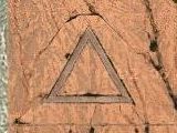
The Bir Tawil Triangle has no roads, but the high-res images show that at least some vehicles pass through, with tire tracks clearly visible in the sand - these appear to be areas where water gathers, with trees growing sporadically, so may be the 'Water Well' from which the area is named.

More information at Strange Maps.
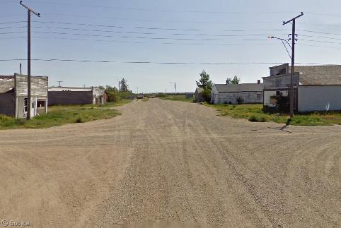
It appears that this might also be a border post.
View Placemark
Actually, (parts of) Antarctica are claimed by quite a lot of nations, but those claims are frozen ( 😉 ) indefinitely by the Antarctic Treaty.
I was mulling over a post on this place, but you beat me to it! Nice job.