The Equator
Thursday, 5th November 2009 by RobK
We featured the Greenwich meridian two years ago on Google Sightseeing, so it's about time we had a closer look at the other global zero: the equator.
Although it is more than 40,000km long, there are surprisingly few towns along the line - much of its length consists of ocean, and on land it crosses large expanses of tropical rainforest.

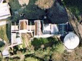
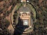
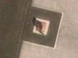
We start our journey, appropriately enough, in the country named after its location: Ecuador. Perhaps the best known monument marking the equator is Mitad del Mundo (Middle of the World), just outside the capital, Quito. These days, GPS-laden tourists are often alarmed to find that the true zero line appears to be 240 metres north of the line on the ground.

It's all a question of which map datum1 you use: The Global Positioning System, along with most online maps, uses the WGS84 datum. So, in the same way that the Greenwich meridian is 100 metres or so away from GPS 0° longitude, the GPS equator (shown in red below) is somewhat north of the Mitad del Mundo line (in blue).
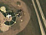
Just to the northeast of the offical Mitad del Mundo monument is a small private museum called Inti-Ñan, which claims to be on the "real" equator. It is, but only on an older datum called SAD69 (shown in yellow). Your GPS won't read zero until you walk into the main road outside.

Heading eastwards through Ecuador, we soon come to the highest point on the equator, and the only place on the line with permanent snow cover: Volcán Cayambe. The summit, just inside the northern hemisphere, is 5,790 metres above sea level; the highest point on the equator itself is some 1,100 metres lower.

On the other side of South America, in the city of Macapá in Brazil, we find a football2 stadium supposedly built right on the equator, with one half of the pitch in each hemisphere. This is the Estádio Milton Corrêa, better known as the Zerão ("Big Zero"), and it's only slightly marred by the fact that the WGS84 equator actually runs just past the southern end of the pitch. A little way to the east, along Avenida Equatorial, is a monument known as Marco Zero.


Next we cross the Atlantic to Africa. A popular tourist stop in Kenya is this layby on the outskirts of Nanyuki, where a sign (arrowed) marks the location of the equator. In this case it's pretty accurate, being just 20 metres or so south of the WGS84 line. You can usually find enterprising locals here willing, for a few shillings, to "demonstrate" how water flows down the plughole in opposite directions either side of the line. However, it's an urban myth and the demonstration is all down to sleight of hand.


Our last location is in Indonesia, in Pontianak on the island of Borneo. Built in 1990, the Equator Monument is a replica of the marker first erected in the 1920s by Dutch surveyors. It's five times the size of the original, but again it's disappointing to note that it is 120 metres too far north, according to GPS.

One final Google oddity - if you search for the location "0,0", then as you'd expect you get a placemark at the intersection of the equator and the Greenwich meridian, off the coast of west Africa. What's more unexpected is the address that is given: 23208 Glenbrook St, St Clair Shores, Michigan. Is this unassuming neighbourhood the real centre of the universe?


For what it’s worth, people have been to 0,0. It definitely does not resemble a Michigan suburb. http://www.confluence.org/confluence.php?lat=0&lon=0
Curses … I’d been drafting a post like this in my head for a while! However, Rob – you did a much better job than I would have done and had several locations that I hadn’t come across. Nice work…
St Clair Shores, Michigan…home of the above ground pool.
Haha Especially funny as the coriolis force is 0 at the equator anyway. So even if it were true, it wouldn’t work at the equator 🙂
Neat. I wasn’t aware that the different spheroid reference data do indeed have different equators.
When thinking about it, it seems unreasonable to expect them to have the same though 🙂
Very nice geonerd post, I had never heard of SAD69 before.
Where are the two points where WGS84 crosses SAD69?
That I couldn’t say! This page seems to list the offsets from WGS84 of loads of different datums (data?)
http://www.colorado.edu/geography/gcraft/notes/datum/dlist.html
SAD69 is the South American Datum of 1969.
None of the lines (red, yellow, blue) work when i click on the thumbnail.
They won’t appear on Google Maps – I added them to the thumbnail simply to show where they are. See also this site: http://www.therealequator.com/intinan_museum.html
Man! I always believed the water draining thing. Especially after seeing it at that Inti Nan thing.
They also do another thing: at the equator, you’re supposed to be able to balance a raw egg on a nail. If you manage to do it there you get this certificate. I was way to hung-over to manage. Fortunately I now know it was probably a fake as well!
In São Tomé and Príncipe, the equator crosses the small Rolas Islet (Ilhéu das Rolas). There is also an equator monument to honor the portuguese geodesist and cartographer Gago Coutinho who demonstrated the equator’s passage in the islet. Check http://upload.wikimedia.org/wikipedia/commons/8/82/Equator_Sao_Tome.jpg to see the monument.
Small Business owners are largely forgotten. Thats why I only focus on them. I have experience several members of my family file bankruptcy due to small business failures. I also I suffered through 2 destroyed businesses due to failure however, in my failings I have learned some of the secrets to success. (Who can say they know it all?)www.onlineuniversalwork.com