Novaya Zemlya: The Extreme of Europe
Monday, 9th May 2011 by Kyle Kusch
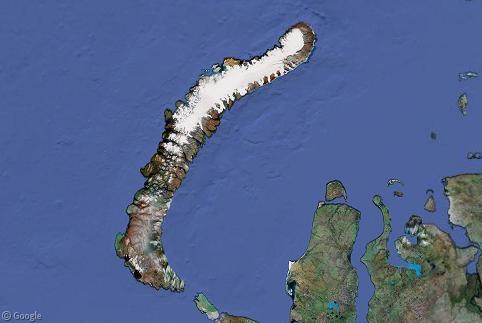
Novaya Zemlya (“New Land”) is a large Russian landmass located at the northeasternmost extreme of Europe. The rugged Arctic islands have one of the most severe climates on Earth and were also home to over 220 nuclear tests between 1955 and 1990.
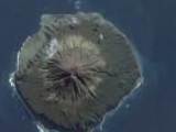
Approximately the size of Austria, Novaya Zemlya consists of two main islands, Severny (northern) and Yuzhny (southern), along with numerous smaller islands. The archipelago is actually a northern extension of the Ural Mountains, from which it derives its long, skinny shape.
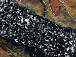
The entire archipelago can get sealed in by ice for much of the year. Google Earth imagery captured this massive wall of ice choking off the west end of this fjord. On the east side of Novaya Zemlya, imagery taken at a different time shows pack ice breaking up and slowly heading out into the Kara Sea.
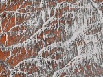
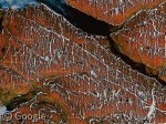
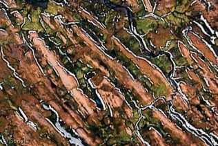
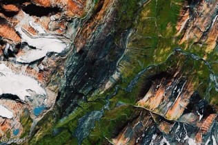
Novaya Zemlya was covered for millennia by a glacial ice sheet. As the ice sheet advanced over the islands, it scoured the bedrock below, leaving giant parallel striations and scrapes across the landscape eventually filled by rivers and creeks. When these creeks freeze, it gives the impression from above of snow-covered tree branches or tinsel hanging from a Christmas tree.
On Yuzhny Island, we see a drumlin field – parallel mounds of glacial till left behind by the advancing ice.
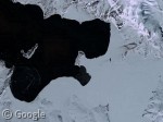
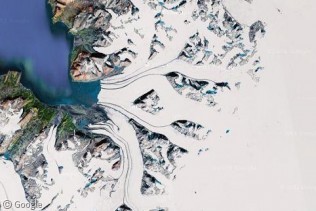
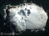
Severny Island is nearly completely covered in glacial ice to this day. Here, we see a cluster of glaciers come together as they flow toward the Barents Sea. The black stripes are moraines; lines of soil and debris scraped off the mountainside. Once the glacial ice reaches the sea, icebergs calve from the glacier’s tongue into the water.
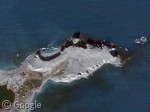
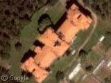
At the northern tip of Severny Island lies Cape Zhelaniya, the northeasternmost point of Europe at 76°57′N, 68°34′E. The Soviet Union constructed a small base here that was actually shelled by the German Navy during World War II. During the Cold War, the cape became a secret station for experimental nuclear tests, and later a weather station. The station’s buildings at the west end of the cape are still intact.
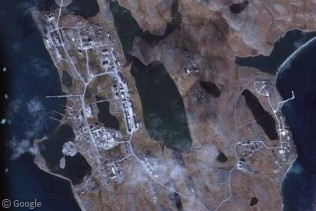
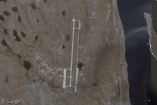
Amazingly, there are over 2,700 people living in Novaya Zemlya, of which 2,600 live in the only major settlement, Belushya Guba. Largely home to military personnel and their families, the town is being looked to as a future oil and mining hub as Arctic shipping lanes develop. Just to the northeast of Belushya Guba is the major airport of the archipelago at Rogachevo, which receives two scheduled flights from the mainland each week. Rogachevo was founded in the 1950s as a staging base for long-range bombing missions.
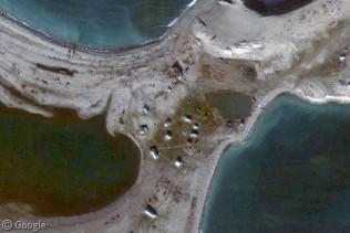
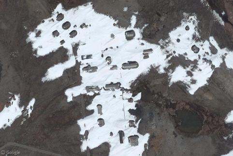
While there isn’t a large amount of high-resolution imagery for the islands, there are some goodies to be found, such as the remains of Cold War-era buildings at Bashmachnyy, where old base buildings can be seen falling apart as they are slowly reclaimed by the wind, ice and snow.
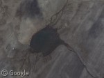
Most infamously, Novaya Zemlya was home to the most powerful nuclear explosion ever recorded: the 1961 detonation of the Tsar Bomba. The 27-ton bomb produced a 50-megaton blast that obliterated everything within a 55km (34 mile) range and broke windows 90km (56 miles) away. 50 years on, the massive black scar left by the bomb can still be seen. At the centre of the scar lies this crater-shaped lake.
Today, Novaya Zemlya is becoming popular with cruise ships looking to catch glimpses of the isolated polar bear population that inhabit the islands, as well as their mountains and glaciers. For now, however, Novaya Zemlya remains mostly a military outpost at the edge of Europe.
About the author
Kyle is a jack-of-all-trades geographer and archivist in rural British Columbia and was formerly the proprietor of humble geography blog The Basement Geographer. He enjoys a good game of hockey and a good 30-km walk with a frozen beverage in hand.
“The 27-ton bomb produced a 50-megaton blast that obliterated everything within a 55km (34 mile) range and broke windows 90km (560 miles) away.”
There’s that an extra 0 in that: 90 km is about 56 miles.
bio
Thanks! Now fixed.