European Barge Lifting
Friday, 30th November 2007 by Alex Turnbull
Today we're posting a roundup of the most interesting ways Europe has employed to get canal barges up-and-over stuff. The simplest method is of course a bridge, of which you can see several excellent examples in our previous post, A Canal Across Germany. However sometimes barges need to traverse obstacles that a bridge cannot cross, and Europeland has employed several ingenious solutions to particular geographic problems.
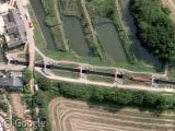
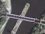
Between Saint-Louis and Arzviller in France, a system was required that enabled the canal to cross the Vosges Mountains. The solution is the Saint-Louis-Arzviller inclined plane, a single structure that replaced 17 locks upon its completion in 1969.
Basically, vessels float into a gigantic bathtub which is then hauled up a 108.7 metre-long ramp at 41°. This vertical change of 44.6 m used to take 8 to 13 hours to traverse, but can now be achieved in just 4 minutes.

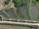
Such canal inclined planes are actually not uncommon, but the Saint-Louis-Arzviller example is probably the steepest. In Belgium, engineers have a more traditionally modest angle, but over a much greater distance - the Ronquières inclined plane climbs 68 m vertically, but is nearly 1.5 kilometres long! This time there are two giant bathtubs (actually known as caissons), and the journey takes a much more leisurely 45 minutes to complete.


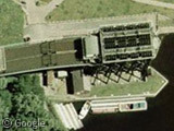
Seemingly on a roll, Belgian engineers are also responsible for the Strépy-Thieu boat lift - an absolutely monumental machine that dispenses entirely with inclines, and just lifts the barges straight up and down in two counterbalanced caissons1. The difference between water levels is 73.2 metres, meaning this is officially the world's tallest boat lift. At least until the new one at the Three Gorges dam is finished anyway...

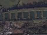
We already posted the world’s steepest flight of locks, the Caen Hill Flight, so instead here's the Foxton Locks - a set of ten canal locks consisting of two "staircases" each of five locks. Because the Foxton locks can hold many boats at once, they've become a very popular location for Gongoozling - the art of watching activity on UK canals. No, seriously - there's a Wikipedia page on Gongoozlers and everything.
The best thing about the Foxton locks however, is that we can actually see a barge in one of the locks.
The UK also has two working boat lifts - the Anderton Boat Lift in Cheshire, England, and the awesome Falkirk Wheel in Scotland (which is unfortunately not available on Google Earth or Maps, but Microsoft's Live Local has a good image of it2).
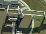
Although both rely on Archimedes' Principle, the Falkirk wheel is unique as it is the only rotating boat lift in the world. Barges enter the wheel at the ends of two opposing 15 metre arms, which then rotate through 180° in five and a half minutes, using only the energy it takes to boil 8 kettles!
Read more at Wikipedia about the Saint-Louis-Arzviller inclined plane, the Ronquières inclined plane, the Strépy-Thieu boat lift, the Foxton Locks, the Anderton Boat Lift, and the Falkirk Wheel.
Or, if you're really interested, "Canal lifts and inclines of the world" by Hans-Joachim Uhlemann seems to be definitive book on this subject.
Thanks to Jel and others.
-
According to Archimedes' Principle, floating objects displace their own weight in water, so when a boat enters, the amount of water leaving the caisson weighs exactly the same as the boat. Meaning that the caissons weigh the same whether they are carrying a boat or just water. ↩︎
-
Browser restrictions apply - most often this means that Mac users must use Firefox. ↩︎
About the author
Alex has decided that his title will be Senior Vice President of Stuff.

Haha, I was imaging how scary it would be to go up that incline in a boat, until I saw the wikipedia article!
Near Bezier / France: View Placemark
The view of the “Plan Incline” in France doesn’t include the great luge run in the basin to the southwest just below the big building (which is the visitors center for the Plan Incline). Hopefully there’ll be a new shot soon; I’d love to see that thing from altitude!
Don
Fantastic bit of engineering the Falkirk Wheel, makes me proud to be British. Unfortunately things like Gongoozling don’t. Only joking I don’t want to upset any Gongoozlers out there, in fact GGSS has made Gongoozlers of all of us.
Any way you don’t really appreciate the Falkirk wheel until you see it working so Youtube to the rescue.
Foxton Locks was, of course, also the site of one of the first experiments in the Saint-Louis-Arzviller style ‘sideways on’ inclined planes. The remains of it show up surprisingly well in GE. There is a useful diagram here.
In Russia they do it rather big – please check out the river lift at Krasnoyarsk hydroelectric dam, located on the Yenisey river within 30 km upstream from Krasnoyarsk:
http://www.e-river.ru/gallery/view.php?id=1413&p=2
Unfortunately the Gmaps is quite low resolution there so one cannot really see it from satellite pictures.