England v Trinidad and Tobago
Thursday, 15th June 2006 by Alex Turnbull
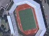
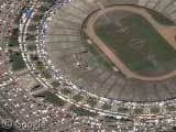
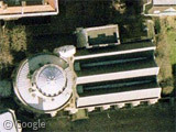
This is the Urban Stadium in Nuremberg...
Erm, no. It used to be the Urban Stadium, it now appears to be the Frankenstadion...
Sorry. This stadium has been renamed the easyCredit-Stadion for the next 5 years. Except... FIFA have renamed it the FIFA WM-Stadion Nürnberg for the duration of the 2006 World Cup.
Well whatever it's called, this is the location of tonight's match between England and Trinidad and Tobago, which despite the odds is promising to be a very interesting match!
More about, er, the stadium in this post at Wikipedia 😉
About the author
Alex has decided that his title will be Senior Vice President of Stuff.
England 1X0 Trinidad and Tobago
England 2×0 Trinidad and Tobago
No Robo dance. So disappointed. 🙁
How much would you Brits be ticked off if I told you I was really kind of rooting for T & T?
Well I wouldnt be too bothered, they did lose- so your loss!
I wouldn’t be annoyed at all, I was totally rooting for T&T! 😀
There’s only one Steven Gerrard