Canadair Planes
Saturday, 15th October 2005 by James Turnbull
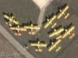
These yellow planes parked in France are aerial water bombers, used to fight forest fires. They are commonly known as "Canadair" planes, after the company who manufactured them (although Canadair has been bought out by Bombardier Aerospace).
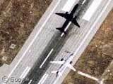
The planes skim along a lake or reservoir as shallow as two metres to collect over 5,000 litres in just 12 seconds. They then drop the water over the forest fire either all in one or as a sustained shower. Here's a photo of one such plane in action.
Thanks: Jerome

here is some more View Placemark
Anyone see that TV show where they tried to prove or disprove the idea that a diver could get sucked up into one of these things and then deposited, dead, on top of a scorched forest? It as quite fun, they rigged up a huge pump and a swimming pool and a dummy. All kinds of fun.
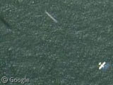
2 more CL215 and CL415
View Placemark
We saw so many of them here in Portugal this summer. 🙁
Too bad this isn’t in high-resolution: View Placemark As I’m pretty sure that the two white spots in the lake are the two Martin Mars waterbombers operated by Flying Tankers: http://www.martinmars.com/ According to the web site, “the world’s largest flying boats ever flown operationally”. Some more pictures: http://www.gotofino.com/sproatlakemarsbombers.html