Mexico City Megapost
Sunday, 29th January 2006 by
Mexico City is the capital city of Mexico and the second largest "Megacity" in the world after the Tokyo area. After centuries of pre-Columbian civilization, Spanish conquistador Hernán Cortés first arrived in the area of Mexico City in 1519. He didn't conquer the city until 1521, after a 79-day siege that destroyed most of the ancient Aztec city. In 1525 the rebuilt city served as the capital of "New Spain" and the political and cultural center of Mexico. The importance of the city was such that the colonies of Cuba, Florida, and the Philippines were administered from it. In the following centuries there were many different governments, rulers and revolutions for Mexico City leading to an extremely varied architectural and cultural style.
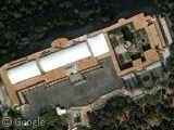
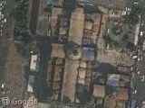
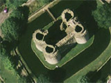
Chapultepec Castle
This castle which roughly translates as "Castle of Chapultepec" or "Chapultepec Palace" is a palace built on top of Chapultepec Hill, in the middle of Chapultepec Park. The palace has had many uses has been used during its history, including Military Academy, Imperial and Presidential residence, observatory and museum. It currently houses the Mexican National Museum of History.
Thank cacafuego
Strange Colours
I'm guessing that this is some sort of image processing bug. As it crops up again, here and here. Anyone got any ideas?
Thanks Carlos & Scott
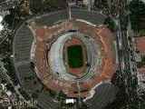
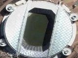
Estadio Azteca
The Estadio Azteca or "Aztec Stadium" was the location of two FIFA World Cup finals in 1970 and 1986 and the only stadium to host 2 world cups. Opened in 1966, it is one of the largest stadiums in the world with a capacity of 114,600. In 1986 it hosted the quarter-final between Argentina and England in which Diego Maradona scored the so called "Hand of God" goal.
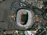
Thanks Carlotto, Eitan Nudel, cacafuego, redstar1, David Barrera, Monasteria, Arturo Hernández & Rod Farley
Big Spiral
I have no idea what this is. Looks like some sort of land-based sculpture.
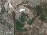
Thanks Larry PDX, Paul Overbeek & Dave
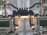
El Zócalo
El Zócalo is a large square officially called "Plaza de la Constitución". The square is surrounded by a Spanish-era Cathedral, the modern "Palacio Nacional" and some ancient Aztec temple ruins which were disovered during building works.
Thanks Eitan Nudel
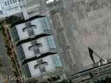
Heroico Colegio Militar
This is the "Heroico Colegio Militar" Mexico's answer to the USA's West Point military academy.
It has some interesting architecture, a huge parade ground and check out the size of the flag and the shadow.
Thank cacafuego
Olympic Stadium
The University Olympic Stadium or "Estadio OlÃmpico Universitario" is a stadium that was built in 1952 and at that time was the largest stadium in Mexico. It has a capacity of nearly 73,000 seats. The stadium hosted the 1968 Olympic Games and was the location for the track & field competitions, football matches, the marathon and the opening & closing ceremonies. It is now the home stadium of the university american football and soccer teams "Pumas de la UNAM" and "Pumas de la Universidad".
Thanks Maite & Elguero

Love the cocacola signing on the seats in the footie stadium
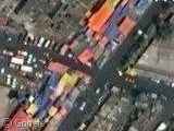
On your second photo, they could be what is called “Over-wheels market”. This are food markets that go changing places week from week, they usually establish on the street. They use for the roof very colorful plastics, usually are pink ones.
Here’s another one near the
Photo #4: This is an open air water deposit to aid in its evaporation called “El Caracol” (The Snail). It holds most of the last water remenants of the water fron the former Texcoco Lake, which has been drying up since the early 1600’s. It’s water is used for industrial purposes and, after it’s evaporation, the collected water is used for human consumption. More info (in spanish): http://www.metro.df.gob.mx/red/estacion.html?id=132 You can see this in a road map of Mexico City here: http://comercial.reforma.com/libre/comercial/mapas/planos.asp?plano=047
Photo #2: Netwalker is probably right about the “market” although tis is probably just an exit of the Metro (subway) system, which are invaded every day by these illegal “merchants” which the government likes to refer to as “informal commerce”. The colorful things are just colored plastics to cover their vending tables. Objects they sell range from cheap plastic toys from china, watches, clothes and food, to pirated software and movies, porn and electronic/electric appliances.
¡Great post!
The colors are from REALLY BRIGHT neon lights… you know those Mexicans loooove their neon!
Nice stadiums, I love going ‘stadium-hunting’ with google local myself… I don’t have any Mexican stadiums at my site, but feel free to check out this post (http://flip.co.in/node/25) anyone that is interested, or just bored! :p
That colourful line, I recon is indeed an image processing error.
“In 1986 it hosted the quarter-final between Argentina and England in which Diego Maradona scored the so called “Hand of Godâ€? goal”
he scored there also the recently known as “best goal ever”, at the same match 😉
The Big Spiral, was a solar evaporator that covered about 800 hectarea. I was built by the Mexican company “Sosa texcoco”. Probably is on of the bigest structures in the Mexico Basin (Anahuac valley).
Texcoco lake was desecated by the spaniard because they could not controlled it, after they destroyed the aztec control damns. Mexico city once was inundated four years!!! in colonial times. It took 20 years to desecate the lake. After that the Mexico Basin have became drier each year.
The strange colours look a lot like this http://homepage.mac.com/helipilot/.Pictures/vistasaereas/TiangusNeza.jpg
Which is “Mercado Sobre Ruedas (small one a week day food market)” according to http://homepage.mac.com/helipilot/PhotoAlbum31.html
The second picture as Fred Say is a “mercado sobre ruedas” or for you english speakers it’s a “Flea Market”. It’s usually done in specifc days of the week because it’s in the street. This is full of street vendors and most of the time they have piracy, illegal stuff and food in this places.
There are some of this markets that have specific porpouses like to sell theft car parts or remade, also there are others for clothes and for many other incredible stuff. I just love ’em.
The colors are because the different things they use to protect the things they sell!
^^ hope that helps!
Here are another maps from Mexico: http://www.my-musik.com/article693.html
to Carlos and Scott: those colors that you see and that keep popping up in several locations in Mexico are the several sometimes hundreds or in special seasons quite a bit more!! those are the “puestos” where people sell their different products like produce, textile etc I mean the regular stuff you’d buy any time or use everyday. This “mercados” (markets) pronounced “mher-coa-doss” can be really small 10 to 15 “puestos” (stands) or you can have hte super merry and entertained ones of nearly 1000 stands, where you can find from a needle to live cattle for sale!!! the one in the caption is from the Aragon Area a popular suburb some 15 miles from the city downtown.
to larry PDX: that is a water treatment dam. this dam in the form of a snail is called the “presa el caracol” (snail dam) and it recyckles the city’s waste water for use in agriculture and other of the city’s possible uses like park watering and street washing.
The colors are, as they have said, markets (not exactly flea markets, but similar). There are a lot around mexico city’s image. For example, a few blocks north-east from the cathedral is a yellow one. http://static.flickr.com/20/70572719_3a8c614320.jpg is a nice example from (almost) street level.
Brazil will win the World Cup this time.
This guy’s a helicopter pilot and has a really cool photo gallery of different places in Mexico City that’ll make for excellent GoogleEarth hunting…
http://homepage.mac.com/helipilot/PhotoAlbum20.html
I’ll start looking for some of those structures myself right now.
Hi, Mexican posting. As most have said, the colorful streets are markets, not image processing error. Fred Bobardo posted a really nice gallery (http://homepage.mac.com/helipilot/PhotoAlbum31.html) in which u can see not only stadiums and the “Basilica of Guadalupe” the most visited catholic sanctuary in the world (even more than the vatican, like 2 million people just the 12 of december, the celebration of the Guadalupe Virgin). In the 5th photo, the Zocalo it’s actually below that pic, its the square plaza with a BIG flag in the middle (well u cant see it from the top). And u can find also in Google Earth the biggest bullfighting ring in the world next to the “Estadio Azul” (Blue Stadium, form soccer club Cruz Azul). Actually Mexico City its reallt beautiful and huge, u should come visit someday :D.
people are stranger
directorio telefonico mexico df
hola tio ahm espero q si lea este comntario. el num de mi casa es (55) 55901001
aver si me habla!
hast aluego!
y felicitaciones atrasadas x sus trabajos el sus filmes y cortos!
Almost everyone is rigth, about those colors you can see in the images. There are to many definitions, some people call them markets in the open, Tianguis (and this is a word from the aztecs, the founders of Mexico-Tenochtitlan), like somebody says, those are also called “mercado sobre ruedas” (or markets on wheels), because everyday they sell their merchandise in a new area of the city (they’re rotating). And by the way, I think this is not a megapost, if it doesn’t have the Basilica…