Arizona [heart]s Oprah
Tuesday, 12th April 2005 by James Turnbull
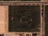
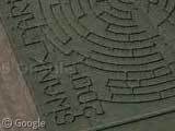
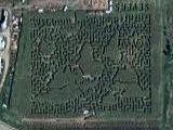
Each Year around Halloween, Arizona's Schnepf Farms carve a maze into their 10-acre corn field and in 2004 they decided to forever immortalize Arizona's love for talk show hostess Oprah Winfrey.
Thanks: Lauren
And News Channel 3, it seems (to the East).
This is the most convincing evidence of the alien nature of crop circles I’ve ever seen.
I live not far from this farm. They do these corn mazes each year around Halloween time. I think they recently did Larry King too.
If I had some land I would write (C) 2005 Google on it to confuse people 😉
The Oprah Winfrey maze / maize in Arizona is just superb, must have taken them ages to do that!!!