Iowa Class Battleships
Friday, 25th November 2005 by James Turnbull
The last battleships ever built by the United States are known as "Iowa class" and were named after the states of Missouri, Wisconsin, New Jersey and Iowa. The four ships were built in the 1940s and between them have served in almost every major U.S. battle between then and the 1990s when they were decommissioned. There's loads more detail about the ships on the Wikipedia page.
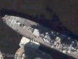
The USS Wisconsin is currently berthed in Norfolk, VA. It is in an Inactive Reserve status, meaning that it is still a commissioned warship of the U.S. Navy, but not in active service.
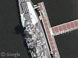
The USS New Jersey is now a museum at Camden, New Jersey.
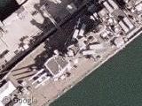
The USS Missouri is berthed in Pearl Harbour, Hawaii.
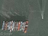
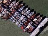
The USS Iowa is part of the previously posted Suisun Bay reserve fleet in California (it's the big one on the end). The Iowa is the only ship of the four which is currently not open to the public but has recently been acquired by Stockton, California where it will be a museum.

Thanks: Robert Amos for compiling links to all four ships and many other people for submitting at least one of the ships.


Apropos of nothing, Camden New Jersey, where the USS New Jersey is berthed, has the highest violent crime rate of any American city.
High Resolution Photographs of Peral Harbour has been added to Google Earth lately. You can have a nice view of the USS Missouri…
the 1990s when they were decommissioned. THANK-YOU CLINTON ADMINISTRATION FOR MAKING US SAFE
all but the USS Missouri was decommissioned befor Clinton took office so i beleve that would be the first Bush Administration you have to thank for making us safe BB61 Iowa in 1990 BB62 New Jersey 1990 BB64 Wisconsin 1991 BB63Missouri the begining of 1992 Bill Clinton took office Jan 1992
All of these ships were decommissioned on the theory that they would be of no use in the ballistic/guided missle age. It might be nice to have their armament augmented by missles and the vessels returned to active duty.
The USS Iowa is not in Stockton….YET! Check out the latest at http://www.visitstockton.org/USSIowa.htm
The Iowa will never be in Stockton as the city has withdrawn it’s bid. Vallejo took it up next but is now considering bankruptcy as I believe the Mare Island site would need expensive dredging.