Peru (heart) Large Type
Thursday, 15th December 2005 by James Turnbull
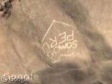
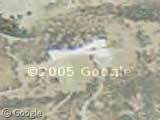
Nowhere in the world do they like putting large type on the hills as much as they do in Peru. A lot of these messages refer to political parties such as the UPP (Union for Peru) and Somos Peru so were presumably written around the Peru elections of April 2001.
There's absolutly loads of things, a lot of which I either can't make out in Google Local or can't understand as I don't speak Spanish, such as here, here, here, here and here! You might find it easier to view them all on our embedded map or in Google Earth.
Thanks: Tim, Ali, Niklas Bergius, Uwe Rose

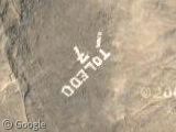
I’m spanish and Somos Peru means We’re Peru. Toledo is a spanish city. And the others, I don’t know.
I´m spanish too, Toledo is a city in Spain and also in Peru (much cities in South America have names from cities in Spain) but it seems like some politic content as the president of Peru is called “Alejandro Toledo”. Others look like political content too, as you can see for example “Montenegro es la voz, alcalde 2002” (Montenegro is the voice, mayor for 2002) or “Unidad Nacional” (National Unit)
tres bien
bien
Actualy that “Toledo” is the name of the guy who actually won the presidential elections in 2001, Alejandro Toledo
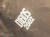
Dibos is the guy that ran for major and won that same year for “La molina” district (Where I live) Actually I live close to those signs, I might be able to get pictures, but we are running for new elections this year so I don’t think the same names are still written 🙁 (Toledo cant run again)
Toledo en España es una ciudad,pero en Peru es el nombre de su presidente !
Pretty cool. I am wondering if you can find a satelite photo of the writing on the hill on this Cusco Photo.