Hadrian’s Wall
Tuesday, 26th May 2009 by RobK
When the Romans invaded Britain in the 1st century AD, they never quite managed to conquer Caledonia - the area now known as Scotland.
We'll never know whether the Roman army felt it was too much like hard work to defeat the fearsome northern tribes, or were simply under-attired for the fearsome Scottish weather; either way, in AD 122 the Roman Emperor Hadrian ordered the construction of a wall to defend his territory from the lands to the north.

Hadrian's Wall stretched for 80 Roman miles (73.5 modern-day miles, or 117km), from the Solway Firth (where the wall is still visible) to the River Tyne (where the wall has vanished, but the fort of Segedunum, which marked its eastern end, has been excavated).
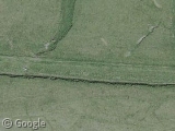
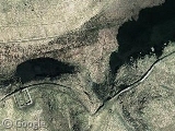
Despite being almost 2,000 years old (and having been heavily plundered by the locals for building materials after the Romans left), a surprising amount of the wall can still be seen today. One of the best preserved stretches is near the village of Gilsland. Here you can also see the foundations of the Roman bridge across the River Irthing - although since it was built the course of the river has shifted westwards.
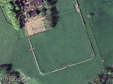
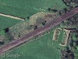
There are an astonishing number of Roman sites in this area, as a look at the Ordnance Survey map shows. Among them are Birdoswald fort; the nicely preserved milecastle 481 (right next to the spot where the railway line slices through the wall); and a couple of Roman camps. The shadows on the aerial photography really show up the traces of old structures and ditches, even where there is little else left on the ground.
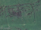
The wall was not a single structure: at various stages in its history it was extended, and separate banks and ditches added. Among the later additions was the Vallum, consisting of three earth banks separated by ditches, running parallel to the wall a few hundred metres to the south. The surviving stretches also show up well in aerial imagery; if you scroll northwards from this point you can see the wall itself.
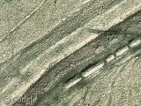
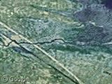
In many places, the builders used the natural topography to help create a formidable barrier. One spectacular stretch of wall follows a steep rocky ridge, Highshield Crags.
The low angle of the sun creates some dramatic shadows here - and if you zoom right in, you can see the shadow of a sycamore tree in the hollow between two ridges. This location, known as Sycamore Gap, will be familiar to fans of the film Robin Hood: Prince of Thieves: it's the spot where Kevin Costner rescued a small boy from the dastardly Guy of Gisbourne.2

Read more about Hadrian's Wall at Wikipedia. The 84-mile-long Hadrian's Wall Path National Trail follows the course of the wall, and its website has a great gallery of ground-level photos.
About the author
Rob is a subeditor and freelance writer from Hampshire, England, who enjoys travel both real and virtual.
Cool. Walked it’s length a few weeks ago; Highshield Crags are the most interesting parts by far; Newcastle less so. (if Google photograph Newcastle for Street View at 10pm on Saturday night, you’ll see why!) Just to be entirely pedantic – you say we’ll never know why the Romans didn’t invade Scotland, but that’s not true. The ruling elite at the time made sure wars were being continuously fought on certain fronts, to stop regional commanders getting too complacent and/or rebellious. Hadrian’s Wall provided a great taxing opportunity too, as they could charge for every local and product that passed through the gates. If the Romans had really wanted to, they could have conquered Scotland, but there was no strategic necessity; nothing against the Scots, you understand, but there was no major force or army there to be a threat to the greater Roman Empire.
Apologies for the error Ian. I blame the editor*, who is clearly trying to paint a slightly more impressive picture of his homeland…
After all, who would want to be from the country that the Romans couldn’t be bothered to conquer?
The Romans obviously were unaware of the extensive Irn Bru reserves Scotland has. Just think how powerful their empire could have been if they had had the power of Irn Bru to embolden them.
That’s because, like Astérix’s potion, only two people are allowed to know the formula at any one time. As they’re never allowed to travel together, the Romans were’nt interested.
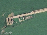
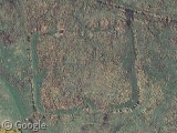
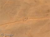
This looks like a pretty well preserved fort not far from Sycamore Gap:
https://www.googlesightseeing.com/maps?p=&c=&t=k&hl=en&ll=55.013316,-2.329794&z=18
Isn’t it amazing? So many centuries ago, and still you can see the remains of what the Romans built in the landscape of today!
dr. R. – that is Vindolanda, which has been excavatd and is open to the public, with a Roman Army museum. See http://www.vindolanda.com/
And yes it is amazing how much of the Romans’ influence can still be seen in Britain.